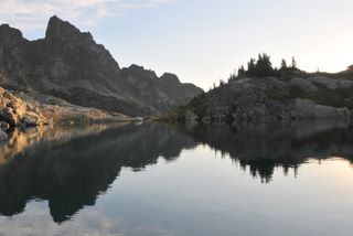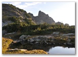
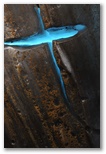
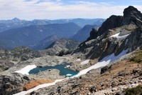
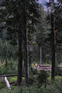
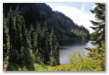
Pelton Basin from Cascade Pass
Mostly sunny, 45-70
Route Photo Gallery Packing list
Packing up seemed to take forever and by the time we were ready to go, it was too late to leave.
We left around 8:30 the next morning. On the way we stopped at REI to get a map, at Cascadian Farms
near Marblemount to buy a blueberry ice cream cone for David, a blueberry shortcake for me and a
pint of blueberries to pack with us to enhance our breakfast granola, and on a whim, at the
wilderness information station in Marblemount where I discovered that we needed a permit to camp
anywhere in the North Cascades National Park, including Pelton Basin, our intended destination.
No permit was available for our first night at Pelton Basin so we decided on Sahale Glacier camp
instead. I'd originally thought to stay therefore but had been deterred by the 20% chance of
thunderstorms in the forecast. Now I'm grateful that Pelton Basin was full our first night.
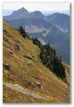
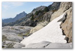
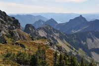
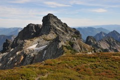
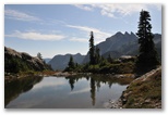
Sahale Arm
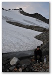
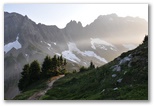
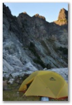
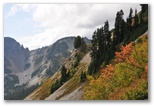
The 4000' up from the trailhead to Sahale Glacier was tough but the scenery was stunning and we
spent a beautiful night camping under the full moon on a bedrock ledge just 100' below the glacier.
We arrived at the trailhead at 1PM but didn't start hiking until 2. The first 3.7 miles up to
Cascade Pass were sunny and quite warm with abundant biting flies which fortunately were neither
quick nor particularly hungry. We competed to see who could kill the most with one slap but the
Pumping water
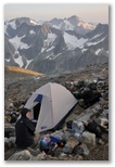
Camp
best either of us could do was 3. As we continued up Sahale Arm a light westerly breeze kept them at
bay. We reached camp 5 hours after leaving the trailhead. We no doubt could have made better time
had we not stopped what seemed like every 50 feet or so to take another photo of the incredible
scenery. Arriving at camp at 7 we still had enough daylight to get set up, pump water from a little
stream at the foot of a nearby snowfield and eat our sandwiches which we'd planned to have the next
day for lunch. I was too tired to cook and also was concerned that my smoked tuna was already fully
warmed up and might not safely keep another 18 hours.
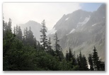
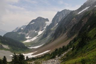
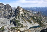
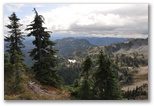
From our camp mountains extended as far as we could see to the east, south and west though smoke and
haze in the air limited the view somewhat, particularly in the afternoon and evening. The broad
white mass of the Sahale Glacier topped by the rocky triangular summit of Sahale Peak blocked our
view to the north. We spotted only one fire, which was burning on a very steep ridge above the road
about three miles down from the trailhead. In the morning it would be scarcely discernible but by
evening it would produce a plume of blue smoke which blew up and across Boston Basin to dissipate
somewhere over Sahale Peak above us. A ranger we met on the hike in explained that the fire had
been ignited by lightning several days earler and was only burning about a tenth of an acre. By
the time we hiked out, after two days of sun and afternoon breezes, the fire had clearly expanded to
cover several acres. There were larger fires around though, and their smoke formed brown and blue
bands of haze to the east and west.
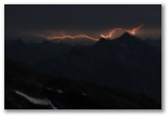
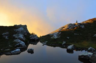
Lightning over McGregor Mountain
During the night just enough of the wind persisted to rustle our tent fly with a sound like a mouse
scampering overhead; though I awoke several times to look for the mouse I never found one. On one
occasion a flash of light lit up the tent and I looked out to see lightning far off on the eastern
horizon. I dug out my camera, braced it on a rock and tried to photograph the storm but the
lightning diminished quickly in both intensity and frequency. I caught a few small flashes using
1-2 minute exposures at f8, ISO 400. Under the full moon, about 3 minutes at f8 would be the
equivalent of a daylight exposure.
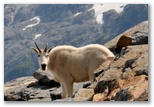
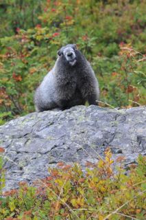
Mountain Goat
In the morning I awoke to find a mountain goat licking the ledges where we'd urinated the night
before. For several hours it wandered through from camp to camp cleaning up the rocks and paying
little attention to hikers and their cameras. I was concerned that he might get into our packs or
chew on the straps while we were out exploring but he disappeared for most of the day, not showing
up again until after we'd returned to camp. Once the snow had softened up some we hiked up onto the
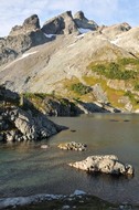
glacier, following other hikers' tracks. After surmounting the initial slope we found two
crevasses, both maybe 30' deep and about 6' wide at their widest point, and we crossed both somewhat
to the left of where they closed up, again following other tracks and probing the shallow dip in the
snow marking the trace of the crevasse. Not totally safe but we heard from a couple other hikers
that even the ranger had said it was probably OK. In any case, not even the climbers who roped up
to ascend the peak used a rope on the glacier. Seeing them roped up on the peak discouraged me from
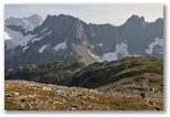
trying to scramble up it so we settled for a lower summit about a quarter mile southeast of the
peak. Breathtaking views down into Horseshoe Basin and south across the valley. On the way down we
scrambled down some ledges and into a large schrund/crevasse on the east edge of the glacier. It
was about 20' wide and 10-15' deep with still-fresh snow carpeting the floor where it was still
roofed over. David loved it and I followed him farther into the cavern of snow and ice than I would
have ventured otherwise. On the way out we found a man and his son from Maine (Bruce and Ben) from
Bangor, Maine peering down at us from the edge of the crevasse, so we explained to them how to get
in. We ended up hiking out with them the next day.
I cooked up Phad Thai for a late lunch, not bad for a freeze-dried meal but not very good for Phad
Thai. Afterwards we packed up while the next occupant of our site waited patiently. Before
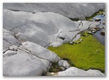
Underside of glacier
starting down we hiked east across a snowfield to explore where the lower edge of the Sahale Glacier
was breaking up into angular blocks of white ice on a ledgy knoll. It was a fascinating spot
because we could crawl under the edge of the glacier and look up into small crevasses in the ice
overhead. The underside of the ice was fluted, the ridges and valleys reflecting the countours of
the rock over which the glacier had recently been sliding. The turquoise fissures of the crevasses
made a striking contrast with the brown mud-dotted surface of the ice.
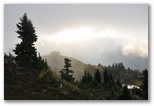
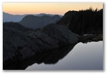
Smoke over Cascade Pass
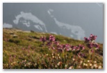
Pedicularis sp.
The late afternoon light on the way down Sahale Arm was even more beautiful than it had been during
the hike up so we made lots of photo stops. The sun had set by the time we reached Cascade Pass. We
took turns visiting the composting toilet, then pumped water from a stream partway down into Pelton
basin. When we reached camp it was just barely light enough to see the trail. A friendly camper
pointed out the bear bin and a nice campsite in an open area surrounded by tall trees. By the time
we had set up the tent, the deer we'd heard about had already showed up to clean up the rock on
which I'd just urinated. We ate a sandwich each and went to bed.
A full moon was spreading angular patches of light across our camp the one time I got up during the
night. In the morning the sky was overcast and a west wind was blowing fog through the treetops.
Searching for the composting toilet I ran into the doe lying in the middle of the trail keeping
watch on the camp but when I returned with my camera she'd moved on. I found her not far down
the trail, then followed her gaze to two spotted fawns trailing another doe across the brushy slope
above me. Overhead peaks began to appear behind the fog. I hiked a little higher and realized that
our overcast was just a thin layer of fog flowing over Cascade Pass and down into the basin. I took
lots of photographs of the mountains veiled by fog, then took some more as we hiked back up to
Cascade Pass.
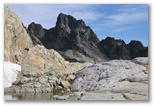
Though we'd been considering heading out in the morning in order to get back to Bellevue in time for
lunch at an Indian buffet, the sunshine above the pass enticed us on another exploration, this time
following a thin trail southeast from the pass across a steep slope, up over a shoulder and down to
the first of the three glaciers overlooking Pelton Basin. We decided not to cross the glacier;

though there were no breaks in the snow cover we could discern traces of numerous crevasses between
us and Cache Col at the top of the glacier. We explored the small caves in the ice down near the
toe of the glacier then hiked back up over the bare ice surface, crossing several crevasses which
though small were still intimidating. Our trail was the jump-off point for the Ptarmigan Traverse
and as we started back towards Cascade Pass we saw a couple of parties heading out for the multi-day
trip. The traverse is just Class 3 rock and glacier crossings with some moderately steep snow
according to one party we talked to but the trail from the pass was bad enough, with a sketchy
crossing of a very steep and rocky dirt bank being the worst point.
We couldn't find Indian food in the hinterlands of northwestern Washington so we settled for Chinese
in Mount Vernon.
8/11/2009 Good bye Striper Rain, 65
It rained yesterday for the first time in a long time. In the morning the guage held a half-inch of
water and the soil was damp down about two inches. Thanks to watering recently the zucchini are
beginning to produce again in the garden but the kiwi won't recover. The 100+ temperatures combined
with dry wind during the last week of July killed all the new growth. David's clematis, growing
next to the kiwi, wasn't harmed at all; it's still putting out tendrils, climbing the baling twine
David rigged up for it.
Today we took Striper down to Pat and Shirley's to join their goats. He's been grieving for a herd
since Wheezer died, spending most of the day hiding in his goat-house and breaking out in loud
bleating at random times. He's no longer willing to be tied up out in the field or along the road
to forage unless one of us is within sight. We would be his preferred herd but we don't have time
so Pat's goats will have to do. During the ride down in the back of Susan's van he looked out the
window, clearly perplexed at how rapidly the world was passing by. When we turned him out into
Pat's pasture the other goats pushed him around a bit. He didn't resist much at first, just got out
of their way, but when they persisted he reared up and made as if to butt them back. We all agreed
that he had very fine butting form and was generally a very good-looking goat. Well-mannered too.
Though I think he found his new company a little coarse, he seemed nonetheless glad to have a herd
again and didn't wander far from them.
8/28/2009 Back to School Increasing clouds, 75
The boys returned to school this morning.
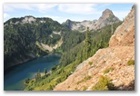
9/14/2009 Chikamin Ridge hike, Gold Creek trailhead to Joe Lake Mostly cloudy, 60 Birds
Chikamin Lake from Chikamin Ridge
Chikamin Ridge - north side
Chikamin Ridge - south side
Here's
my route for the four day hike
and here's
a photo gallery from the hike,
and here's
a bird list.
Twenty three years ago I hiked in one day from the Gold Creek trailhead to the western summit of the
Chikamin ridge and back again, about 15 miles and 4500' up and down. I remember seeing numerous
trout in the shallow outlet of Joe Lake and ascending a gully to the ridge through meadows so steep
they made me dizzy, though in retrospect I concluded that the vertigo was caused by going too long
before lunch. It being October then, the rocks on the very crest of the ridge were covered with
ladybugs, or flying ants, I forget which. In any case they didn't bother me and I tried for my part
not to sit on them.
This summer I decided I wanted to go back there and maybe check out Chikamin Lake on the other side.
On the map the far side of the ridge looked less steep than the near side. Google shows ledges and
a small snowfield but it's hard to tell how steep the route to the lake might be. In August on our
way out to New Hampshire we flew right over Gold Creek and I got a perfect view of the ridge and the
lake beyond it. The ridge looks like a go. The lake is alpine but ice free, tucked in between talus
and cliffs just east of the Cascade Crest. The outlet drains through an area of meadows and ledges
before tumbling off a headwall down to the lower elevation lakes along the Pacific Crest Trail. On
the Internet I found a report of hungry 8-15" trout in Chikamin Lake - 15 years ago. Maybe they would
still be there.
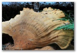
Mushroom in the woods
The boys and I made plans to hike in there over Labor Day weekend but the weather didn't cooperate.
The snow level dropped to 5000' and more than a foot of snow was forecast for the high country. My
next opportunity to take off was a week later and I did, though alone because the boys had school.
Packing up 50lbs of gear and food took me half of Sunday and Monday morning as well so I didn't leave
the trailhead at Gold Creek until 2:30PM. The stratus blanket moving over the mountains from the west
wasn't breaking up for another 30 miles beyond the crest so I set out under the overcast.
The trail hasn't changed much in twenty years. It starts out on a network of roads serving vacation
homes in the woods. I counted more birds there than farther up the trail in the deep woods - more
variety of habitat. I photographed a Red-breasted Sapsucker on a cottonwood trunk but couldn't get
a good view of a greenish warbler in a willow thicket. I saw several more greenish warblers on the
hike and wasn't able to get a good look at any of them. I suspect they were Wilson's, mainly
because I've seen other species migrating south this fall but haven't seen any Wilson's yet. (Note -
they were more likely MacGillivray's or Orange-crowned; Wilson's' apparently migrate in late August.)
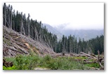
Avalanche path
The trail was in good shape as it entered the woods; WTA has been working on it recently. Signs warned
of severe trail damage up ahead though, and a day hiker that I met warned me that he'd lost the
trail in a tangle of blown-down logs so thick even his dog couldn't get through. After an hour and
Joe Lake camp
a half, I found out what he was talking about. A massive avalanche swept off the summit of Alta
Mountain a few years ago, plunged off a cliff and mowed a path a third of a mile wide across the
valley and up the other side. It took me a half an hour to make it across, balancing along logs and
following gravel bars by the stream. The un-maintained track across the brushy area beyond the
Unmaintained Joe Lake trail
Alaska Lake turnoff was easy by comparison though I lost the trail where it crossed the stream out
of Joe Lake. I would have saved myself some steep duff-scrambling had I looked at the map at that
point. I didn't cross the stream until a couple hundred feet below the lake, then I found the trail
almost immediately on the far side.
There was only one camp near the lake, on a little knoll with big firs just south of the main lake
outlet. It was dirty; previous campers had left cut-up onion on a log and dumped their leftover food
behind a stump. The sun had already set so it was too late to look for another camp. I set up my tent
on a reasonably clean spot, stashed the bear canister and hung my extra food while it was still light
enough to see. No bears overnight fortunately, just a couple of owls calling.
9/15/2009 Chikamin Ridge hike, Joe Lake to Chikamin Lake Sunny, 45-65
Birds
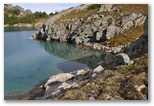
Chikamin Lake, on the north side of Chikamin Peak about 9 miles northeast of Snoqualmie Pass, is a
tough place to get to so I was surprised when I arrived to find another tent parked in a meadow just
below the outlet. I didn't meet the owner although I saw him picking his way across the talus on
the north side of the lake. I was flyfishing near the outlet, mostly just to see what was there
since I'd already kept three cutthroat for supper.The trout were hanging along the shore in small
groups of mixed- size fish, anywhere from 8" to perhaps 15", my estimate of the largest trout I
hooked and lost. The largest one I kept was about 12". They remind me of
the trout at Black Joe Lake; some are silvery and others more colorful with
greenish color on the back and rosy sides. They're in reasonably good condition, particularly the
fat 13" fish I caught and released in the lowest of the three lakes.
I only hiked about 3 1/2 miles today, 2300' up and 1100' down, but it was a tough hike, first the
bushwhack up from Joe Lake to the Pacific Crest trail, then the meadow-scramble up the Chikamin
Ridge and finally the lower part of the descent to the lake, where I had to lower myself down the
last pitch hanging off the handle of my ice axe. I was tired, though not as bad as yesterday, so I
took it slowly and carefully, using the ice axe on steeper sections for stability. From Joe Lake I
Pacific Crest Trail above Joe Lake
followed a gully up through the slide alder near the northeast corner of the lake. The alder wasn't
bad but the meadow became quite steep as I approached the PCT. I followed another stream gully,
easy scrambling, up the northwest end of the Chikamin Ridge. It ascends a hundred yards or so
Chikamin Ridge ascent
beyond the high point on the crest trail, not far past where the PCT crosses a talus slope. I
detoured left out of the gully then back through some krummholz to bypass a notch with three chock
stones. At the next fork I kept left, crossing back over a gentle rocky ridge to gain the head of
my original gully. Crossing the gully at that point was an intimidating traverse across loose
gravel on top of steep ledges, but once past that an easy grassy slope ascended to the right below a
set of cliffs to gain the ridge on a carpet of crowberry.
It was very pleasant up there, sunny with a cool breeze from the east. I found a place to park,
took off my boots and socks and my shirt and set them out to dry, putting on a dry shirt and my
fleece because the breeze was too cold to go shirtless. I ate bread and tomatoes and the smoked
Chikamin Ridge
tuna left over from yesterday's lunch along with several handfuls of mixed salted nuts from Costco.
The sweet pecans are a little scarce; otherwise it's a very good mix. Hawks were moving through. I
watched a couple of Sharpies and a larger accipiter, probably a Cooper's, drift southward. The
Cooper's returned to catch an updraft off the sunny slope below me, circling up and almost out of
sight faster than I would have believed possible. I called Susan on my cell phone and watched a brown
Northern Harrier sail off to the south while we talked. After my socks were all dried out I packed
up again. Before leaving the ridge I set the camera on a rock and photographed myself reenacting the
last few steps of the hike up to the ridgetop.
From the ridge a ledgy knoll blocked my view of the route down to the lake. The map shows an easy
ridgewalk down to the saddle on the crest above the lake, but that route would require traversing
the steep-looking talus on the north shore of the lake. I decided to gamble on a more direct route
down over the ledges to the outlet of the lake. It was a good route until the last eight feet or so
where the ledges dropped down to briefly steep meadow. To bypass the dropoff I would have to climb
back up 200' or more then descend steep talus. Rather than doing that, I found a spot where it
looked like I could downclimb but a missing handhold made the drop a little longer than I could
reach. Wedging the pointed end of the head of the axe securely in a crack, I lowered myself off the
shaft and that way was able to touch down safely into the grass. In retrospect it would have been
more prudent to lower the pack with my bear-rope then scramble up and around without it.
Safely down on the ledges by the lake I looked for signs of trout before digging out my rod. I
hadn't seen any rises at Joe Lake, which may be closed to fishing anyhow, and I didn't see any rises
out on the wind-riffled dark blue surface of Chikamin Lake either. Then in the transparent
turquoise water a few feet out from shore I spotted a trout, not a really big one but big enough.
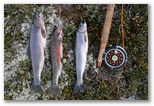
I rigged up a weighted leech fly, black with a gold bead head, and cast it awkwardly out into the
lake. Good casting form was not required - I got a strike on the first cast, and the second and the
third too, but the trout weren't contacting the hook. I brought the fly in and clipped off its long
black tail and hooked a somewhat skinny 9" silvery cutthroat on the next cast. Within 5 minutes I
had two more, the third one a little larger and fatter. Enough for supper. I switched to a dry fly
and bent the barb down; fishing a dry fly would be more fun because I'd be able to see the strikes. It
would cast more gracefully too. I caught and released several more 9-10" trout then decided to try
from some ledges on the other side of the outlet stream. There I did equally well, even hooking a
trout quite a bit larger than the ones I'd caught so far. It thrashed heavily on the surface for a
few seconds then came off. Motivated then, I fished for another twenty minutes or so but didn't see
anything nearly as large again.
I told Susan that I was probably going to camp down at Glacier Lake but I spent too much time fishing.
It'll make for a longer day tomorrow; I'll just have to get an early start. The other tent was
parked in the best flat spot near the lake so I explored down past the second little lake and found
a flat grassy bench at the top of the headwall overlooking the valley which runs down to Spectacle
Lake. A low rise blocks the view of the site from the boot track heading down to Glacier Lake but
it's only a short walk to the stream for water. The site looks out to the east so I'll get sun
early, and the breeze is dry so the tent shouldn't get too wet with dew.
By the time I got the tent set up the sun had dropped behind Chikamin Ridge but I rinsed off in a
shallow ledge pool above camp anyhow. I don't like crawling all sticky with the day's sweat into my
sleeping bag if I don't have to. My sponge bath was a little cold but well worth it. I cooked up
the trout and supplemented them with a cup of curried lentils, a slice of bread, another tomato and
more mixed nuts. Also had some more Brie for an hors d'oeuvre again tonight. The Brie is a nice
touch; I'll have to do that again.
By flashlight I buried the trout bones away from camp and stashed the bear canister among the rocks
not far enough away from camp. I should have cooked farther from camp too but it will probably be
OK. My fellow hiker up the hill didn't seem to be taking any bear precautions. Not that there are
likely to be any bears up here anyhow; the local huckleberry bushes are all barren.
9/16/2009 Chikamin Ridge hike, Chikamin Lake to Rampart Ridge Partly cloudy, 50-65
Birds
I didn't leave Chikamin Lake much earlier than I left Joe Lake the day before. I took camera and
flyrod out before sunrise and fished and photographed all the way around the lowest of the three
Chikamin lakes. The previous evening I'd caught and released a fat 13" cutthroat there and I
thought there might be more but there apparently were not. I saw only one trout in the clear water,
a big one which appeared out of the deep to look at my fly and decided against it. I was using
the same fly as last night and it was probably the same trout too, and smart enough not to make the
same mistake twice in 12 hours. With the camera I took a bunch of OK photos. The image equivalents
of skinny 9" trout, they were adequate but not impressive. Up at the main lake I caught a couple of
those trout and decided that they weren't worth carrying with me all day until suppertime so I
released them.
I did meet my fellow camper, caught him napping in his half-disassembled tent after an early
morning photo outing. I didn't catch his name or a website where he posts his photos - too bad
since it would be interesting to see what he found up there. I mostly asked him about the route
down to Glacier Lake. It turned out the directions he gave me weren't entirely accurate but they got
me there.
The hike down to Glacier Lake was probably the most interesting segment of the whole trip, really
fine ledge hiking interspersed with meadows, bits of forest and a crazy jumble of angular boulders
just above the lake, with spectacular views throughout. I was glad I didn't try to rush through it
the previous afternoon. The campsites at Glacier Lake, which gets more traffic than Chikamin, weren't
as appealing either. Somewhat pressed for time, I didn't try fishing; I'll save that for next year
because this is a hike I want to do again.
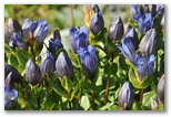
Gentians at Glacier Lake
After a stop to pump water at the outlet of Glacier Lake, I followed a boot track west above the
lake shore to a valley, then south up the valley to a shoulder at about 5400'. Steep but not bad
was how the camper at Chikamin Lake accurately described it. Clouds began to appear around the
Tadpoles in the tarn
Tarn above Glacier Lake
jagged peaks north of Chikamin Lake as I crossed the shoulder and within a few minutes, more stratus
was rolling over the north end of Rampart Ridge ahead of me. I hiked up the Pacific Crest trail a
Towards Little Alta Mountain
quarter mile or so then traversed down to the foot of the talus apron through colorful orange
mountain ash and low huckleberry scrub, scattering golden-crowned sparrows in front of me like
grasshoppers. I followed the bases of series of talus slopes along the east side of the ridge up
past Alta Pass towards the summit of Little Alta Mountain. The high-bush alpine huckleberries below
Alta Pass were loaded with berries. I picked my tupperware full in 15 minutes. Just shy of the
summit of Little Alta I cut around to the right below a little cliff, thereby avoiding the steepest
section of that ascent.
Lila Lake in the sun
During lunch in the sunshine (most of the time) on the shoulder of Little Alta, I watched the cloud
shadows play across the flats from Lila Lake to Rampart Lakes. Two sharp-shinned hawks cut across
the slope below me, both too quick for me to follow with the camera. One was pale brown, the other
very dark, the hue of Raw Umber if I were to paint him. I called Susan again, surprised to find
that I had a better signal than I'd had a thousand feet higher on top of Chikamin Ridge.
The prospect of descending the steep meadow from Little Alta Mountain down to Lila Lake had me
a little nervous during lunch but once I started down I discovered a trail. Though a bit loose on
the steeper pitches, it wasn't bad overall.
At Lila Lake I met another solo hiker who asked me about Alta Mountain. I told him that I thought my
older son might have been conceived on the ledge where we were standing. He volunteered that he
carried the gun for defense against bears and cougars; until then I hadn't noticed the big holster
on his hip. I guess that's the nature of solo hikers - they tend to carry on odd conversations. We
speculated as to whether he'd ever see the cougar if one attacked him and agreed that he probably
wouldn't. He'd never seen a cougar in the wild (nor have I) but he did see a Wolverine once at
Marmot after Lila Lake
Image Lake up by Glacier Peak. I was impressed. I explained how he could get up to Alta Mountain
via a beautiful ridge walk from where we were overlooking Lila Lake. He asked if he could make it
up Alta and still get back to his car by dark and I told him I thought he could. He gave me a card
so I could contact him to hike together in the future. It's not easy to find strong hikers who can
go out in the middle of the week. As he set off I heard the tinkling of bear bells. If I hiked
with him I wouldn't have to worry about bears. A minute or so later I realized he was headed the
wrong way for getting up onto the ridge to Alta but he was already out of sight. When I get out
I'll have to send him an email and find out if he made it to the top, and back to his car before
dark.
I took the wrong boot track out from Lila Lake (should have looked at the map again) and had to
bushwhack across another slope covered with ripe huckleberries to gain the trail along the ridge to
Rampart Lakes. The cloud cover had coalesced into a gray blanket and the breeze felt bleak. When I
flushed a small trout from the shallows near the outlet of Rampart Lake I stopped to fish but caught
only one even smaller cutthroat. On my first visit to Rampart Lakes years ago I recall 8" trout
competing for the grasshoppers I tossed into the water but during
a trip two years ago I couldn't find either trout or grasshoppers. I was glad
to see there were still trout here, even if they were small.
After freeze-dried mushroom pilaf (edible but not incredible) and another sponge bath, this one
using water heated on my stove after supper, I packed up and with about a half hour of good light
remaining, headed up the trail to the higher of the two saddles south of Rampart Lakes. Just over
the ridge and just in time I found a little flat hollow with a patch of grass big enough for my
tent.
Sunrise from Rampart Ridge
Partly cloudy, 45-70
A few rain showers passed over during the night so I assumed the morning would be overcast and
planned to sleep in. Sometime after first light I awoke to a pinkish glow and peered out to see a
mystical scene - a bank of fog glowing in front of me as it caught the orange light of sunrise. I
grabbed the camera, dashed out in my shorts and scampered around barefoot snapping photos before the
color faded into the ordinary light of day. Within 5 minutes the show was over. I dressed and
hiked up the ridge until my toes warmed up again.
Descending to Lake Lillian I found the gentians I photographed two years ago. For some reason I had
Lake Lillian
pictured them in memory as having fringed petals. They didn't; their petals had entire margins just
like all the other gentians. I'd been looking forward to those particular gentians ever since I
began planning this trip; now that I actually saw them, they were pretty but nothing special.
I didn't catch any fish in Lake Lillian either. I saw a few rises well out in the lake but didn't
raise any trout to my fly either in the sun or the shadows. The trail climbs above the lake to
negotiate a cliff then drops down to the outlet again so I kept the rod out when I started up with
the pack again. When I spotted a dipper ahead of me along the shore I dropped the rod and pulled
out the camera. Without stopping to take off my pack I crept down the steep bank. Dippers don't
usually allow close approach but this one didn't seem too concerned about me. I spent probably half
an hour slowly stalking the dipper as it foraged along the shore, rested for a few minutes under an
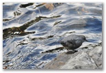
Dipper foraging
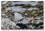
Dipper on the move
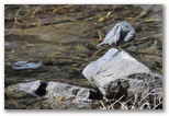
Dipper preening
Dipper napping
overhanging ledge, then hopped onto a rock to stretch before moving out of sight around the ledge.
It seemed to be moving only one way around the shore so after retrieving the fly rod I negotiated
the steep ledge over to the outlet. Approaching the shore again I spotted the dipper while I was
still sheltered by some small firs. Dropping the rod and pack, I lay down on a rock to wait with my
camera. Within a minute the dipper came into view and gave me a whole series of close-up shots,
some even in the sunshine, as it worked its way along the waterline in front of me. Satisfied with
the dipper photos I packed up my fly rod and headed home.
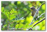
Yellow-rumped Warbler
Along the high section of the trail between Twin Lakes and Mt Margaret I came across the
Boletus
edulis patches I was looking for. The big mushrooms were of mixed ages; a few were fresh enough
to harvest. Even those were at least a week old and all were at least partly buggy but I bagged a
pound or two. Along the way I met Tim and Sandy. Seeing my camera, Tim asked if I posted my photos
to a website. Surprised that someone would be interested, I wrote down "brianpen.com" for him. He
told me that he lives at Hyak and posts video snow reports from the Snoqualmie Pass area on
TheSnowTrooper.com. He suggested that
I might want to go backcountry skiing with them sometime. I agreed. Sandy was photographing
mushrooms with her cell phone, planning to show the pictures to a friend who might be able to
identify them for her, so I pointed out the boletes and explained how to identify them. I showed her
the pieces of mushrooms that I'd collected, took one out and took a bite, then offered her a piece.
I don't remember if she took me up on my offer but the piece I tried tasted so good that I ate the
rest of it while I hiked on towards Mt Margaret. Firm and white with a sweet nutty flavor, it was
surprisingly tasty for a raw mushroom.
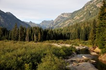
Chikamin Ridge from Gold Creek
I stopped for a rather late lunch when I broke out of the woods at the top of the clearcut area.
Lots of thin-leaf huckleberries, the dark ones, there so I dug out my two tupperware containers and
filled them both with enough tangy berries to make two pies or to spice up a couple of weeks' worth
of granola breakfasts. The hike down to the trailhead was warm and gravelly. I must have relaxed
my guard because I slipped and nearly fell more in that short easy section than I had on the whole
rest of the hike. At the trailhead I retrieved the bag with my running stuff, hiked down the road
another half mile or so then stashed the pack and r an four miles back to my car. Despite the first
half being all downhill, it was not an easy run.