Brian's Journal - October 2009
Journal Home | Previous | Next (3) Top Yellow-rumps Red Top Aasgard Pass Reunion Mt Washington Black Mt
10/07/2009 AM clouds, PM sun, 40-65
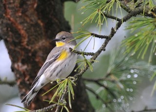
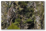
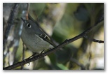
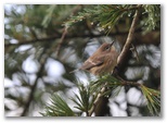 Lots of Yellow-rumped Warblers moving through this past week, typically 20-30 at a time in the row of
aphid-infested poplars behind the house. We hear their chorus of "chik" calls all through the day.
At certain times of the day they seem to concentrate on the southernmost poplar which stands at the
Lots of Yellow-rumped Warblers moving through this past week, typically 20-30 at a time in the row of
aphid-infested poplars behind the house. We hear their chorus of "chik" calls all through the day.
At certain times of the day they seem to concentrate on the southernmost poplar which stands at the
 back corner of the workshop. I climb up onto the workshop roof with my 300mm lens and stand about
six feet from the lower branchs of the tree, waiting for the warblers to come close. Eventually
they do; I've snapped close to five hundred pictures over the past week though most of them
weren't worth keeping. It's tough to get clear views of the birds gleaning among the leaves.
The cedar in front of the house makes a better backdrop; I've been able to get a few photos from
the garage roof, including the first two displayed here.
back corner of the workshop. I climb up onto the workshop roof with my 300mm lens and stand about
six feet from the lower branchs of the tree, waiting for the warblers to come close. Eventually
they do; I've snapped close to five hundred pictures over the past week though most of them
weren't worth keeping. It's tough to get clear views of the birds gleaning among the leaves.
The cedar in front of the house makes a better backdrop; I've been able to get a few photos from
the garage roof, including the first two displayed here.
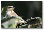
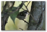 In addition to the butterbutts, over the past month from the same vantage point I've managed to get
closeups of ruby-crowned and golden-crowned kinglets, black-capped and chestnut-backed chickadees,
bushtits, brown creepers, cedar waxwings, downy woodpeckers, a red-breasted sapsucker, a Steller's
Jay, and orange-crowned, yellow, black-throated gray and Nashville warblers. The first wave of
warblers, all but the yellow-rumps, came through around the 10th of September. There may have been
earlier migrants, in particular the Wilson's warblers, but if so I missed them. After a lull around
the middle of September the yellow-rumped warblers, which had been numerous in the mountains during
my Chikamin Ridge hike, showed up here in the lowlands as well.
In addition to the butterbutts, over the past month from the same vantage point I've managed to get
closeups of ruby-crowned and golden-crowned kinglets, black-capped and chestnut-backed chickadees,
bushtits, brown creepers, cedar waxwings, downy woodpeckers, a red-breasted sapsucker, a Steller's
Jay, and orange-crowned, yellow, black-throated gray and Nashville warblers. The first wave of
warblers, all but the yellow-rumps, came through around the 10th of September. There may have been
earlier migrants, in particular the Wilson's warblers, but if so I missed them. After a lull around
the middle of September the yellow-rumped warblers, which had been numerous in the mountains during
my Chikamin Ridge hike, showed up here in the lowlands as well.
Note the missing tail
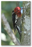
Red-breasted Sapsucker
Brown Creeper
Ruby-crowned Kinglet
Golden-crowned Kinglet
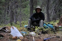
On lunch break
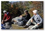
I considered trying to squeeze in one more backpack trip during the long period of mostly sunny and dry weather after the first of October but the deck needed painting and I wasn't quite up to more time alone in the woods so after Susan and I got the deck mostly done I took off with Pat to Red Top instead. I hadn't been there in a couple of years and after a day and a half of digging I remembered why - the eggs are never as numerous in reality as they are in memory. That and I already have plenty of them in piles around the workshop. It's still a thrill though when one of those round agate modules rolls out of the rusty soil as you pick away at the wall of your hole.
The road hadn't been graded since my last visit; some sections are studded with rough rocks, passable but slow. I found Pat's camper still cooling down at the trailhead parking area when I arrived mid-afternoon, having been delayed by a meeting with a retirement planner who told me that if I continued with my plan of working just part of each year, we'd probably still be OK financially. That was welcome news. Pat is already retired; I've had the summer off but am anticipating going back to contract work next month.
Gus found me as I approached the digging area down in the woods north of the lookout. Pat was already deep in a hole, only his head and shoulders showing above ground with a big pile of rocks and dusty soil behind him. He hadn't found much yet but had cleared out an area a couple feet across and four feet deep. I set to work clearing out a hole just uphill from his, a promising spot with a wide exposed bank to work at. By the time we quit for the day we'd worked about three hours and I had several good-sized eggs and a handful of smaller ones. Pat, demonstrating once again his remarkable knack for picking good holes, had about twice as many eggs as I did.
Overnight the temperature dropped into the mid-20's. We both stayed in Pat's camper, appreciating the lights and the propane heater. For supper I steamed fresh corn along with potatoes and carrots, all from Pat's garden. Lacking butter for the corn we used some Brie cheese I'd brought for lunch instead. Pat, who'd never tasted Brie before, decided it made a pretty good butter substitute. After supper we sat at the table in the dim light of the 12-volt lamp overhead and talked some, about rock saws and vegetable gardens and how there were alot of yellowjackets around Pat's place this year.
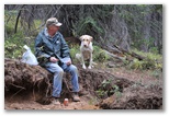
Pat and Gus at lunch
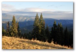
View east late afternoon
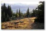
Heading back to camp
The sun came out at the end of the day but the breeze was biting. Odd how in mid-winter 27F feels warm but in early October it seems to penetrate whatever you put on. Approaching the car it occurred to me that I could be home with Susan by 8PM but I didn't say anything to Pat. The plan was to spend another night and anyhow, he'd have quite a bit longer drive home than I would. We were quite comfortable again in his camper, with more of Pat's sweet corn for supper and an Ibuprofen for dessert.
10/10/2009 Aasgard Pass hike Partly cloudy, 25-32
 After breakfast Pat and I packed up quickly and were on our way down the hill by 8:15. The stars
had been bright when I'd gotten up at 3AM but the sky was overcast again in the morning with a mid-level
altostratus layer thick enough to block the sun. Considering a hike, I jogged up the road to an
outlook from which I could see Mt Stuart. The summit was visible though faded somewhat by a thin
fog of precipitation but there didn't appear to be any significant new snow, acceptable hiking
conditions. I considered heading home via Yakima the way Pat was going, perhaps stopping at Chinook
Pass for a hike on the way, but I'd never been to Colchuck Lake and it was just an hour away this
morning. Moreover it was Sabbath so even if I went home I wouldn't be finishing up the deck until
tomorrow anyhow. If I hiked up to Colchuck Lake I could eat at El Caporal in Cle Ellum on the way
back and still be home by 9:30 or so.
After breakfast Pat and I packed up quickly and were on our way down the hill by 8:15. The stars
had been bright when I'd gotten up at 3AM but the sky was overcast again in the morning with a mid-level
altostratus layer thick enough to block the sun. Considering a hike, I jogged up the road to an
outlook from which I could see Mt Stuart. The summit was visible though faded somewhat by a thin
fog of precipitation but there didn't appear to be any significant new snow, acceptable hiking
conditions. I considered heading home via Yakima the way Pat was going, perhaps stopping at Chinook
Pass for a hike on the way, but I'd never been to Colchuck Lake and it was just an hour away this
morning. Moreover it was Sabbath so even if I went home I wouldn't be finishing up the deck until
tomorrow anyhow. If I hiked up to Colchuck Lake I could eat at El Caporal in Cle Ellum on the way
back and still be home by 9:30 or so.
I started up a little after 10AM. The trailhead parking lot was full; I got the last space. The overcast was developing a little definition, a good sign, and the temperature was a chilly 27F. Other than a sore knot in the left side of my lower back from all the digging the day before I felt good. That's the spot I first aggravated on a snowshoe/snowboard hike some 15 years ago up one of the big open hillsides east of town in Sun Valley on a March morning. The wind out of the higher mountains was kicking up a fierce ground-blizzard on the exposed ridge and it was all I could do to stay upright and keep frostbite at bay. Somewhere up there I wrenched my back but didn't notice it until I thawed out back down at the car. Today it gave a little twinge every time I planted my left foot all the way up to Aasgard Pass but I mostly didn't notice it and it didn't get any worse all day.
 With a few brief photo stops I made it to the lake by noon. The forest in the valley is
mostly lodgepole with evidence of a burn several decades ago. Much of Icicle Creek up to the
trailhead burned 7 years ago (the morels we picked out of the ash along the Icicle Creek road the
following summer are still bagged up in the downstairs freezer) so I tend to think of big fires in
the area as a recent phenomenon, a consequence of warming climate compounded by years of fire
suppression, but the prevalence of lodgepole pine throughout the area indicates that fire has been
active there for a long time. On the way up to the lake the composition of the forest changes to
fir (and spruce?) with limber/whitebark pines mixed in. As they are across the western mountains,
many of the pines are dead or dying from insect infestations, facilitated (I think) like the fire
by warmer conditions in recent years. Bad news for Clark's Nutcrackers which rely on pine seeds as
a staple of their diet. I heard a few on the way down. I noticed very little bird activity on the
way up; they seem to lie low on cold overcast mornings. I listened particularly for crossbill calls,
having seen white-winged crossbills a few weeks ago at Joe Lake, but I heard none, probably due to
the lack of cones on the firs.
With a few brief photo stops I made it to the lake by noon. The forest in the valley is
mostly lodgepole with evidence of a burn several decades ago. Much of Icicle Creek up to the
trailhead burned 7 years ago (the morels we picked out of the ash along the Icicle Creek road the
following summer are still bagged up in the downstairs freezer) so I tend to think of big fires in
the area as a recent phenomenon, a consequence of warming climate compounded by years of fire
suppression, but the prevalence of lodgepole pine throughout the area indicates that fire has been
active there for a long time. On the way up to the lake the composition of the forest changes to
fir (and spruce?) with limber/whitebark pines mixed in. As they are across the western mountains,
many of the pines are dead or dying from insect infestations, facilitated (I think) like the fire
by warmer conditions in recent years. Bad news for Clark's Nutcrackers which rely on pine seeds as
a staple of their diet. I heard a few on the way down. I noticed very little bird activity on the
way up; they seem to lie low on cold overcast mornings. I listened particularly for crossbill calls,
having seen white-winged crossbills a few weeks ago at Joe Lake, but I heard none, probably due to
the lack of cones on the firs.
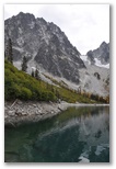
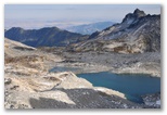
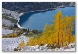
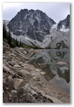 Where the trail approached the lake I dropped down to the shore. Colchuck Lake is not as attractive
as many alpine lakes because the water level fluctuates. A dam at the outlet is the likely culprit. At
low water the lake is surrounded by a ten foot high bathtub ring of bleached boulders and barren
dirt. The exposed shoreline along the far side of the lake, accessible via a makeshift bridge of
driftwood across the outlet channel, appeared to provide a more direct route to the head of the lake
than the up and down trail through the woods along the west shore. I went for it, taking a chance
that the one section I couldn't see, where a cliff appeared to drop right down to the water, would
prove to be passable. It was, though clambering over (and in one spot, under) boulders along the
shore was probably slower than hiking the trail would have been.
Where the trail approached the lake I dropped down to the shore. Colchuck Lake is not as attractive
as many alpine lakes because the water level fluctuates. A dam at the outlet is the likely culprit. At
low water the lake is surrounded by a ten foot high bathtub ring of bleached boulders and barren
dirt. The exposed shoreline along the far side of the lake, accessible via a makeshift bridge of
driftwood across the outlet channel, appeared to provide a more direct route to the head of the lake
than the up and down trail through the woods along the west shore. I went for it, taking a chance
that the one section I couldn't see, where a cliff appeared to drop right down to the water, would
prove to be passable. It was, though clambering over (and in one spot, under) boulders along the
shore was probably slower than hiking the trail would have been.
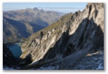
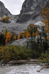 A sandy beach fringed with willow, fir and larch offers waterfront campsites at the head of the
lake. The trail up to Aasgard Pass starts up behind one of the nicer spots. After winding through
young firs and willow scrub for a couple hundred feet it starts up talus. The way could be
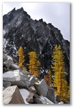
difficult to follow were it not for large regularly-spaced cairns. About half way up the route
swings to the left to get around a cliff band capped with colorful larch. Towards the summit the
A sandy beach fringed with willow, fir and larch offers waterfront campsites at the head of the
lake. The trail up to Aasgard Pass starts up behind one of the nicer spots. After winding through
young firs and willow scrub for a couple hundred feet it starts up talus. The way could be
difficult to follow were it not for large regularly-spaced cairns. About half way up the route
swings to the left to get around a cliff band capped with colorful larch. Towards the summit the
 trail scrambles up through a ledgy area. That section was very slippery due to several inches of
snow compacted on the tread; I found the going easier off the trail where I could hop from rock to
rock. A few hundred feet from the top the wind picked up and it got cold fast. I stopped and put
on wind pants (Taku, a steal on sale last month at REI for $50), an extra fleece shirt and my cuddly
Monkey Man fleece (on sale at LL Bean two months ago for $100).
trail scrambles up through a ledgy area. That section was very slippery due to several inches of
snow compacted on the tread; I found the going easier off the trail where I could hop from rock to
rock. A few hundred feet from the top the wind picked up and it got cold fast. I stopped and put
on wind pants (Taku, a steal on sale last month at REI for $50), an extra fleece shirt and my cuddly
Monkey Man fleece (on sale at LL Bean two months ago for $100).
A woman had stopped at the same spot to wait for the rest of her party so we got to talking. They were doing a one-day loop through the Enchantments, 18 miles total with 12 left to go. The rest of her party was apparently having a tough time down in the snowy section. At the rate they were going they'd be doing at least the last 6 miles after dark. I dug out some lunch and sucked mouthfuls of almond butter and honey off the blade of my knife, sticking my freezing fingers into my armpits between bites to ease the pain. At 25F there was no way to spread the honey on my bread. The woman's party began to arrive, including one guy without gloves. He was trying to hold onto his hiking poles and complaining that his hands were numb. I searched in my pack, thinking I might have forgotten to take out the heavy fabric gloves I was digging with yesterday. No such luck. It occurred to me that someone else in his group might have extra gloves, or lacking those, then socks, so I asked the woman's husband I think, who seemed to be the leader. Right away he dug out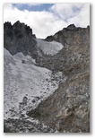
 his extra socks and gave them to the guy with numb hands. My first good deed of the day.
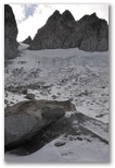
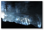
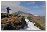
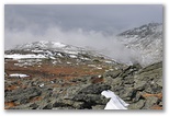
By the time I reached the pass the overcast was breaking up. The sunshine was very pleasant though it wasn't melting anything. Feeling strong I decided to see if I could get up Dragontail Peak by scrambling up to the right of the senescent glacier southeast of the pass. The glacier is clearly melting away year by year. Rocks which have fallen onto the snow over the years are now perched on little hummocks of blue ice. Along the edges of the glacier shallow ice caves have opened up under the talus. I traversed up across the low angle ice relying on crusty new snow for traction. That worked most of the time. The scrambling was tougher than it looked - lots of smearing up steep ledges but fortunately frequent talus shelves limited the exposure. I made it up to just over 8400'
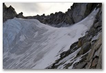
 at the base of the summit cliffs. With crampons and an axe I could have traversed across the top of
the glacier and probably gained the ridge but that will have to wait for another trip. The descent
back to Aasgard Pass took another 40 minutes so I ended up starting down at 4PM, exactly an hour
after my planned turnaround time.
at the base of the summit cliffs. With crampons and an axe I could have traversed across the top of
the glacier and probably gained the ridge but that will have to wait for another trip. The descent
back to Aasgard Pass took another 40 minutes so I ended up starting down at 4PM, exactly an hour
after my planned turnaround time.
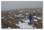
 With photo stops I reached the lake outlet at 5:45 via the trail, a faster route than the rocky
shore I'd followed on the way up. The descent of the snowy section near the top of the pass
required considerable care. Other than campers along the lake I saw no-one on the remainder of the
descent until I caught up to a young woman and her 5-year old daughter on the Lake Stuart trail
while still over a mile from the trailhead. It seemed unlikely that they would make it out before
dark so I asked if she had a flashlight. She did not. At the last minute I'd stuck an extra
flashlight in my pack, the lightweight solar-powered light I bought at Costco a couple of weeks ago, so I
gave that one to her and dug out the LED headlamp for myself. They started down the trail while I
repacked my pack and she must have really hustled because it took me quite a while to catch up to
her again. By that time it was already getting a little difficult to spot the roots and rocks in
the trail. I asked if I could hike with them and that was fine with her. Even with a light I don't
particularly like hiking alone after dark, and all the more so since my headlamp batteries were old
and gave barely enough light to see the ground. Her daughter talked almost continually to whichever
of us would respond so the time passed quickly. The woman takes her daughter out hiking every
weekend. She drove all the way from Seattle to hike up to Colchuck Lake but decided on Lake Stuart
instead because they started so late. "Not that pretty", she said. According to the daughter Dad
builds houses. Also he's brown. I didn't ask why he didn't join them on their hikes. When we
reached the trailhead at 7:15 a little light remained in the sky overhead but the woods were
completely dark; it would have been very difficult to follow the last half mile of the trail without
the flashlight. At the trailhead she gave me back the light, told me how grateful she was and said
"God bless you". Too late it occurred to me to respond "He already has", for I too was grateful for
their company and for the opportunity to help. Two good deeds in one day.
With photo stops I reached the lake outlet at 5:45 via the trail, a faster route than the rocky
shore I'd followed on the way up. The descent of the snowy section near the top of the pass
required considerable care. Other than campers along the lake I saw no-one on the remainder of the
descent until I caught up to a young woman and her 5-year old daughter on the Lake Stuart trail
while still over a mile from the trailhead. It seemed unlikely that they would make it out before
dark so I asked if she had a flashlight. She did not. At the last minute I'd stuck an extra
flashlight in my pack, the lightweight solar-powered light I bought at Costco a couple of weeks ago, so I
gave that one to her and dug out the LED headlamp for myself. They started down the trail while I
repacked my pack and she must have really hustled because it took me quite a while to catch up to
her again. By that time it was already getting a little difficult to spot the roots and rocks in
the trail. I asked if I could hike with them and that was fine with her. Even with a light I don't
particularly like hiking alone after dark, and all the more so since my headlamp batteries were old
and gave barely enough light to see the ground. Her daughter talked almost continually to whichever
of us would respond so the time passed quickly. The woman takes her daughter out hiking every
weekend. She drove all the way from Seattle to hike up to Colchuck Lake but decided on Lake Stuart
instead because they started so late. "Not that pretty", she said. According to the daughter Dad
builds houses. Also he's brown. I didn't ask why he didn't join them on their hikes. When we
reached the trailhead at 7:15 a little light remained in the sky overhead but the woods were
completely dark; it would have been very difficult to follow the last half mile of the trail without
the flashlight. At the trailhead she gave me back the light, told me how grateful she was and said
"God bless you". Too late it occurred to me to respond "He already has", for I too was grateful for
their company and for the opportunity to help. Two good deeds in one day.
As usual I stopped at El Caporal in Cle Elum for supper. The salsa and chips were tasty; the Burrito Relleno fat and featureless. Next time I'll go back to the Burrito Vegetal, which though similar has perhaps a little more flavor.
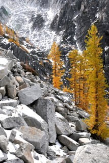
Larches part way up the pass
I started up a little after 10AM. The trailhead parking lot was full; I got the last space. The overcast was developing a little definition, a good sign, and the temperature was a chilly 27F. Other than a sore knot in the left side of my lower back from all the digging the day before I felt good. That's the spot I first aggravated on a snowshoe/snowboard hike some 15 years ago up one of the big open hillsides east of town in Sun Valley on a March morning. The wind out of the higher mountains was kicking up a fierce ground-blizzard on the exposed ridge and it was all I could do to stay upright and keep frostbite at bay. Somewhere up there I wrenched my back but didn't notice it until I thawed out back down at the car. Today it gave a little twinge every time I planted my left foot all the way up to Aasgard Pass but I mostly didn't notice it and it didn't get any worse all day.
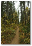
Lodgepole along the trail
Fir forest below the lake
Along the far shore 2
Along the far shore 1
View up Aasgard Pass from the beach
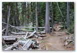
The route mostly on the left.
The route mostly on the left.
Larches and Dragontail Peak
A woman had stopped at the same spot to wait for the rest of her party so we got to talking. They were doing a one-day loop through the Enchantments, 18 miles total with 12 left to go. The rest of her party was apparently having a tough time down in the snowy section. At the rate they were going they'd be doing at least the last 6 miles after dark. I dug out some lunch and sucked mouthfuls of almond butter and honey off the blade of my knife, sticking my freezing fingers into my armpits between bites to ease the pain. At 25F there was no way to spread the honey on my bread. The woman's party began to arrive, including one guy without gloves. He was trying to hold onto his hiking poles and complaining that his hands were numb. I searched in my pack, thinking I might have forgotten to take out the heavy fabric gloves I was digging with yesterday. No such luck. It occurred to me that someone else in his group might have extra gloves, or lacking those, then socks, so I asked the woman's husband I think, who seemed to be the leader. Right away he dug out
Dragontail Peak route
(lower left to upper right)
(lower left to upper right)
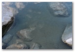
Rock on ice
By the time I reached the pass the overcast was breaking up. The sunshine was very pleasant though it wasn't melting anything. Feeling strong I decided to see if I could get up Dragontail Peak by scrambling up to the right of the senescent glacier southeast of the pass. The glacier is clearly melting away year by year. Rocks which have fallen onto the snow over the years are now perched on little hummocks of blue ice. Along the edges of the glacier shallow ice caves have opened up under the talus. I traversed up across the low angle ice relying on crusty new snow for traction. That worked most of the time. The scrambling was tougher than it looked - lots of smearing up steep ledges but fortunately frequent talus shelves limited the exposure. I made it up to just over 8400'
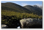
Route to the ridge
Upper Enchantments
Ice Cave
Colchuck Lake from Aasgard Pass
Larches and the lake
Writing in the sand
As usual I stopped at El Caporal in Cle Elum for supper. The salsa and chips were tasty; the Burrito Relleno fat and featureless. Next time I'll go back to the Burrito Vegetal, which though similar has perhaps a little more flavor.
10/21/2009 Mt Washington Valleys - mostly sunny, 55; Summit - fog, 31, W 32 Photo Gallery
 Yesterday evening I suggested to Eric that we do a hike. He'd mentioned Rainbow Ridge which sounded
good to me because I wanted to spend some time in the woods, but this morning he was more interested
in Washington. The forecast called for summits in and out of the clouds with not too much wind,
decent conditions, so I agreed. The route would depend on how much ice there was; we figured
Tuckerman's would be too icy so we chose Boott Spur which kept our options open - we could come back
down Boott Spur or cross over to Lion's Head if that looked OK or even go to the summit.
Yesterday evening I suggested to Eric that we do a hike. He'd mentioned Rainbow Ridge which sounded
good to me because I wanted to spend some time in the woods, but this morning he was more interested
in Washington. The forecast called for summits in and out of the clouds with not too much wind,
decent conditions, so I agreed. The route would depend on how much ice there was; we figured
Tuckerman's would be too icy so we chose Boott Spur which kept our options open - we could come back
down Boott Spur or cross over to Lion's Head if that looked OK or even go to the summit.
 We left Pinkham at 9:40AM in the sunshine and hiked steadily up to the flat spot on the Boott Spur
ridge with just one stop at the overlook not far below treeline where I took a few photos and we put
on clothes - a long-sleeved tech shirt under my slightly damp t-shirt, then a mid-weight tech shirt
and my favorite Monkey Man fleece jacket, a fleece cap and fleece gloves. I hadn't been able to
find my wind shell when I was packing up this morning so I was a bit underdressed for the wind. Ten
minutes later though, we had to strip most of it off again in the sheltered section of trail above
Split Rock.
We left Pinkham at 9:40AM in the sunshine and hiked steadily up to the flat spot on the Boott Spur
ridge with just one stop at the overlook not far below treeline where I took a few photos and we put
on clothes - a long-sleeved tech shirt under my slightly damp t-shirt, then a mid-weight tech shirt
and my favorite Monkey Man fleece jacket, a fleece cap and fleece gloves. I hadn't been able to
find my wind shell when I was packing up this morning so I was a bit underdressed for the wind. Ten
minutes later though, we had to strip most of it off again in the sheltered section of trail above
Split Rock.
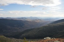 At the flat spot on the ridge at about 4600' we stopped to rest in the sunny lee of a ledge and
ended up eating lunch. Beautiful view down Pinkham Notch to Jackson; with binoculars, and even more
when I zoomed in on a photo taken with the 300mm lens, we could pick out our house over the shoulder
of Spruce. During lunch a stationary roll of cloud developed over the valley, forming on the
windward side and dissipating on the lee side of the first wave crest downwind of Mt Washington.
Boott Spur and the summit, which had been mostly in the clouds when we reached timberline, had
become mostly clear by the time we started up again. From Boott Spur we could see a layer of fluffy
At the flat spot on the ridge at about 4600' we stopped to rest in the sunny lee of a ledge and
ended up eating lunch. Beautiful view down Pinkham Notch to Jackson; with binoculars, and even more
when I zoomed in on a photo taken with the 300mm lens, we could pick out our house over the shoulder
of Spruce. During lunch a stationary roll of cloud developed over the valley, forming on the
windward side and dissipating on the lee side of the first wave crest downwind of Mt Washington.
Boott Spur and the summit, which had been mostly in the clouds when we reached timberline, had
become mostly clear by the time we started up again. From Boott Spur we could see a layer of fluffy
 stratus banked up against the summit and the southern peaks. A pretty stiff breeze was blowing from
that direction but the clouds were dissipating over the flats between us and the Cone. We lingered
in the shelter of Boott Spur for another half hour or so to finish up lunch.
stratus banked up against the summit and the southern peaks. A pretty stiff breeze was blowing from
that direction but the clouds were dissipating over the flats between us and the Cone. We lingered
in the shelter of Boott Spur for another half hour or so to finish up lunch.
 The hike across the flats into the wind was cold. The temperature was only a few degrees above
freezing, the fog closed in on us and my fleece hat didn't do much to stop the wind. At Camel
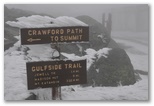
Junction my fingers had begun to warm up again and we agreed to go for the summit via the Davis and
Crawford Paths. Eric led the way. A few hundred feet below the summit we began to run into a fair
The hike across the flats into the wind was cold. The temperature was only a few degrees above
freezing, the fog closed in on us and my fleece hat didn't do much to stop the wind. At Camel
Junction my fingers had begun to warm up again and we agreed to go for the summit via the Davis and
Crawford Paths. Eric led the way. A few hundred feet below the summit we began to run into a fair
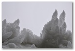
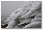 amount of rime ice, probably indicating where freezing level had been the night before. The rime
ice was melting a bit but still in excellent condition. I could have spent an hour or more
photographing the ice formations, feathery-looking spears extending into the wind from every exposed
surface. The ice was best right below the summit, where I noticed that for the first time the fog
was freezing on my fleece.
amount of rime ice, probably indicating where freezing level had been the night before. The rime
ice was melting a bit but still in excellent condition. I could have spent an hour or more
photographing the ice formations, feathery-looking spears extending into the wind from every exposed
surface. The ice was best right below the summit, where I noticed that for the first time the fog
was freezing on my fleece.
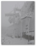
 The buildings and towers at the summit looked very wintry all coated with rime. We made the
obligatory 25' pilgrimmage from the parking lot to the official summit, paid a quick visit to the
observation deck and took shelter briefly in the Observatory building where a group of orange-coated
Observatory volunteers were apparently waiting for a ride down. We didn't stay to talk, lingering
only long enough to check the weather board (31F, 32mph wind) before setting out for Pinkham. We
set no speed records on the descent. My legs had been tired all day and particularly so on the trek
down the Fire Trail. I was glad I'd brought John's hiking poles.
The buildings and towers at the summit looked very wintry all coated with rime. We made the
obligatory 25' pilgrimmage from the parking lot to the official summit, paid a quick visit to the
observation deck and took shelter briefly in the Observatory building where a group of orange-coated
Observatory volunteers were apparently waiting for a ride down. We didn't stay to talk, lingering
only long enough to check the weather board (31F, 32mph wind) before setting out for Pinkham. We
set no speed records on the descent. My legs had been tired all day and particularly so on the trek
down the Fire Trail. I was glad I'd brought John's hiking poles.
Washington from the house before our hike
Boott Spur ridge from the overlook
View towards Jackson
Eric on Boott Spur
View from Boott Spur
Eric at Camel Junction
25' to the summit
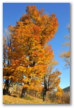
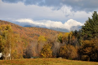
Bright Sugar Maple on Black
Since the hike up Washington with Eric I've been looking for one more opportunity to get out in the mountains before we returned to Seattle, one more sunny day with no obligations. I suggested the ledges on Baldface, one of my favorite hikes, to Eric a couple evenings ago but he didn't want to drive that far. Reluctant to take a whole day alone away from the family, I stayed home and went for a swim with John later in the afternoon instead. Then Saturday was rainy and Sunday was the half marathon so that left only today. Fortunately the weather this morning was perfect.
I wanted a hike where the trees would still have their leaves. On all the higher mountains, most likely including Baldface, the leaves have already fallen, frozen by cold weather and even some snow and swept off by northwest winds. The birches, red maples and most of the sugar maples are already bare, their recently glorious foliage now brown and crisp underfoot. The colors that remain are
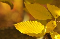
Beech leaves
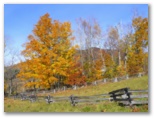
Sugar maples and birches
Black Mountain in background
Black Mountain in background
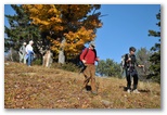
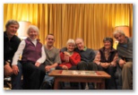
Recalling successful bird photo outings up on the side of Black Mountain last June and the color lingering a few days ago on the slopes below the Knoll, I decided to hike up the trail behind Overlook. No driving required. John thought he might like to come with me, and then Mom. Figuring Susan could keep up with us I invited her and when Sarah showed up she was interested too. I packed some lunch then ate it while we waited for each other to finish getting ready. Hoping for birds I put on the 300mm lens. John and Sarah and Mom brought hiking poles; years of skiing (or perhaps just their years) have taken a toll on their knees. Mom is scheduled for knee-replacement surgery on both knees a week from today, so this would be her last hike on the joints she was born with.
The hike was just what I was looking for. The trail starts out on what was once probably a logging road but is now a grassy path traversing up a gentle wooded slope. About half the trees were bare; filled with light the forest seemed open and inviting. Part way up, the trail ascends through an area which was logged maybe 15 years ago and has grown up with a dense understory of beech, a flood of yellow in the sunshine. Towards the top the way became quite steep and somewhat difficult to follow, marked by low cairns which were nearly smothered in fallen leaves. It occurred to me that this steep trail slippery with dry leaves was more than Mom and John had bargained for but they managed the irregular rocks and short ledgy sections without much difficulty, and slowly enough that Susan, who is unaccustomed to significant uphill walking, was still able to keep up. I had plenty of time to take photos but the telephoto lens was too long for group shots and I didn't bother to change it out. For birds, I heard only a few chickadees and nuthatches. The trees were more interesting, an open mix of spruce, oak and some of the largest hop-hornbeams I've ever seen. Though not more than 20' tall a couple of them were nearly 18" in diameter, impressive for a tree whose trunk is normally less than 6" thick. The stout trunks and delicately shaggy bark reminded us of old apple trees but the tapered crowns with fine twigs are hard to mistake for anything else.
Descending the ski slopes
Mom, Sarah and John on the Knoll
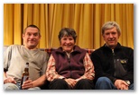
10/28/2009 Boston Rain, 53
The plane was nearly empty; fewer than 50 passengers were on the Jetblue flight to Seattle. That works out to not even one passenger on each side of the aisle per row. The flight attendants said that this evening's flight was an anomaly; usually the plane is reasonably full. I hope so; I like that flight and would hate to see it cancelled.
The plane was nearly empty; fewer than 50 passengers were on the Jetblue flight to Seattle. That works out to not even one passenger on each side of the aisle per row. The flight attendants said that this evening's flight was an anomaly; usually the plane is reasonably full. I hope so; I like that flight and would hate to see it cancelled.
Top Yellow-rumps Red Top Aasgard Pass Reunion Mt Washington Black Mt
Brianpen Home | Journal Home | Previous | Next (3)