


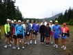
Thanks everyone for a good time
The Light at the End of the Tunnel Marathon was a lot of fun; we really enjoyed seeing
everyone and were glad that so many runners stayed for lunch. Results are posted here.
Hopefully next June the Tunnel will be open again so we can see the Light at the End of the Tunnel again.
Meanwhile, we had a few medals left over after the race so we're putting on another race,
the Tunnel Medal Marathon and Half
on Sunday September 20. Same course, same chili recipe and the same medals. No T-shirts, but the price is right,
just $25 ($20 for Maniacs and Halffanatics) payable on race morning at check-in (6:30-7:30AM). The marathons starts
at 8AM, the Half at 9AM. Hope you can join us then.
Course Change for 2009
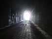
The "Tunnel" in the Light at the End of the Tunnel Marathon is closed to all access
this summer, so the 2009 marathon course will begin at Rattlesnake Lake and run 13 miles up the John
Wayne Pioneer Trail and back to Rattlesnake Lake. Thus, there is no tunnel this year, but the marathon
will go on. See below for more information.
Race Information
The 2009 Light at the End of the Tunnel Marathon will run this coming Sunday June 14, 2009 with starting
waves at 7:00 AM and 8:00AM. Start and Finish are located at the
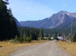
Cedar Falls Trailhead of the Iron Horse State Park,
near Rattlesnake Lake a few miles south of North Bend, Washington. The 2009 course
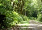
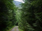
consists of a single out and back leg on the scenic, mostly-forested John Wayne Pioneer Trail in the Iron
Horse State Park. This trail is a well-maintained rail trail with a constant 2% gradient and a hard-packed
gravel surface. Aid stations, some of them self-service like last year, will be located every 2-3 miles
along the out-and-back course. After the race we'll serve a lunch of vegetarian chili, Greeek salad and
various accompaniments to all runners. Runners registered before June 9 will receive a custom-printed,
short-sleeved technical T-shirt, and all finishers will receive a very nice-looking medal.
Directions and Parking return to top
The Cedar Falls trailhead to the Iron Horse State Park is located next to the
Rattlesnake Lake Recreation area, 3.2 miles south of I-90 off of exit 32, which is about 30
miles east of Seattle. Here is a map with directions from Seattle.
There are 40 or so spaces available in the Cedar Falls trailhead parking lot, then when those are
full, park in the upper, gravel lot of the Rattlesnake Lake Recreation Area, the entrance to which
is about 0.1 mile back down the road on the left. The Start/Finish
area is along the trail just to the left of the entrance gate to the state park.
Porta-potties will be located along the trail near the Start/Finish area. In addition, permanent
rest rooms for the Iron Horse State Park Cedar Falls Trailhead are located about 50 yards up the
trail on the right.
Checkin and Packet Pickup
Checkin will begin at 6:15AM for the early start at 7:00AM and at 6:45AM for the 8:00AM starters.
You will receive your shirt and bib when you check in. We are not using chip-timing so there is
no timing chip. The location for checkin and packet pickup is at the Start/Finish area which is
along the trail near the State Park entrance gate.
Registration return to top
Online registration for the 2009 Light at the End of the Tunnel Marathon
is closed but day of race registration will be open between 6:15AM and 7:45AM at the check-in
area along the trail on the left at the entrance to the Cedar Falls trailhead of the
Iron Horse State Park (directions above) . The day of race
registration cost is the same as regular registration, $55 with a $10 discount for
Marathon Manaics, Eastside Runners and Skagit Runners. Runners registering after June
9 or on the day of race do not receive a T-shirt.
Your entry fee buys you a timed marathon run on a scenic rail-trail course,
a fine-looking finisher's medal, aid stations approximately every 2-3 miles
and lunch (delicious vegetarian chili and Greek salad) at the finish.
Note: Contrary to what we posted previously posted on this site, this year's course will not be USATF-certified and therefore is not a Boston qualifier, although it is accurately measured using the mile markers from last year's certified course. We're optimistic that within a year or two we can return to the original certified Tunnel course.
Course Details return to top
The course begins on the trail just to your left as you pass the entrance gate to the
Cedar Falls trailhead of the Iron Horse State Park, 3.0 miles south of I-90 exit 32 at
North Bend. The first tenth of a mile climbs rather steeply up through the woods on
gravel and paved trail before turning left onto the John Wayne Pioneer Trail. For the
next 13 miles to the turnaround the course climbs a barely-noticeable 80' per mile on
the John Wayne Pioneer Trail, a well-maintained rail trail with a hard-packed gravel
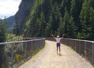
surface. The trail passes through forest and across brushy slopes, along cliffs and
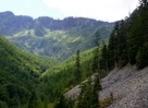
across several high trestle bridges. Openings offer spectactular views of the
Snoqualmie valley and the mountains beyond on a clear day.
On the second half of the course you retrace your steps back to the start, only faster.
The trail surface does have scattered small sharp rocks in places so you'll want to
watch your footing. As trail runs go, it's non-technical. Most runners will be
comfortable running in road shoes but probably not in racing flats.
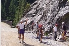
The course is not closed to other users so expect scattered cyclists, walkers and joggers,
as well as rock climbers around mile 7/19. Two days before the 2008 race as I was marking
the course I had to wait for a large black bear at mile 19 to get out of my way, and cougars
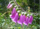
have been seen on the trail as well as deer and elk, toads, garter snakes, small brown
bunnies, cute little hopping mice and rather large slugs. There should be no motorized
vehicles on any portion of the course except at the one low-traffic road crossing at mile
8/18. Spectators are notably scarce but can access the course without too much difficulty
at miles 8/18 and 5/21.
The course will be clearly marked with orange tape and white-flour arrows. Each mile
will marked and numbered as well.
Note:
If you are nervous about heights, you should evaluate whether or not you'll be comfortable on this
course. From the high trestle bridges it can feel like a long ways down to the ground.
Course Map
Here is a map of the course
on gmap-pedometer.com.
Limited Support return to top
The Light at the End of the Tunnel Marathon is a trail marathon with limited access to roads
and aid along the course. You should consider carrying at least one water bottle, particularly if
the weather is warm. You may also want to carry a cell phone. There is a restroom at the start and
a porta-potty at the finish. Along the course there are porta-potties near miles 6 and 20
and there are restrooms at miles 10/16 and shortly before the turnaround. Aid stations with
water and Gatorade are located at miles 2.5, 5, 7.8, 10.5, 13.1, 15.7, 18.4, 21.1 and 23.7
Gu is served at the Garcia aid station at miles 7.8 and 18.4. Several of the aid stations are
self-service, where you'll need to fill your own cup or bottle. A couple of roving course
marshals on bicycles will carry a few supplies as well. At the finish lunch (chili and Greek
salad) and various other munchies will be waiting for you.
Weather
Weather for Sunday is forecast to be cloudy and mild with temperature at the start around 55F
and at the finish around 65F. Much of the course is shaded by trees which keep the course cooler
than it otherwise might be on a sunny day.
Official Disclaimer
Participants in the Light at the End of the Tunnel Marathon acknowledge that running any marathon
carries with it the potential for death, serious injury and property loss. PARTICIPANTS IN THIS
EVENT ASSUME ALL RISKS OF SUCH PARTICIPATION. Participants attest and certify that they are
physically fit and sufficiently trained for the completion of this event.
By electing to participate in this event, participants and waive and release any and all rights and
claims for damages which they may have or which may hereafter accrue to them or their heirs and
administrators, against USA Track and Field, Inc, The Pacific Northwest Association of USATF, Brian
Pendleton and all other volunteers associated with the Light at the End of the Tunnel Marathon, East
Side Runners, Washington State Parks and the City of Seattle and their respective officers, agents,
representatives and/or assigns arising from injuries due to participation in or traveling for this
competition.