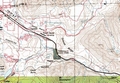

Rattlesnake Lake Marathon course
The Rattlesnake Lake Marathon course begins and ends at Rattlesnake Lake and consists of
a 5 mile out-and-back leg on the Snoqualmie Valley Trail down to North Bend and back, followed
by an 8 mile out-and-back leg on the Iron Horse Trail up to Garcia and back. Both trails are former
railroad grades composed of hard-packed gravel and run mostly through forest. There are several high
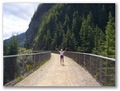
trestle bridges (with sturdy railings) over stream canyons. Openings in the forest, more numerous on
the upper section of the course, provide dramatic views of the mountains along I-90 west of Snoqualmie
Pass.
Miles are marked (but not numbered) with white flour lines on the gravel at side
of the trail and by short sections of orange tape affixed to a nearby bush or tree. Getting lost
should be very difficult though, since the trail is obvious, mostly straight and well-signed, and
all turns will be clearly marked with signs and white-flour arrows. There will be other users
including walkers, runners, bicyclists and rock climbers. Restrooms or Porta-potties are available
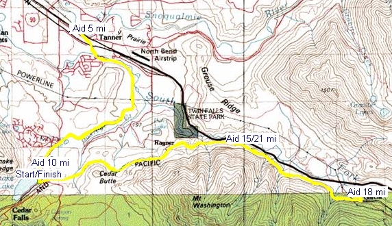
at miles 0 and 10, 16 and 21 and again at the finish.
The start is 0.2 miles above the Cedar Falls Trailhead entrance to Iron Horse State Park.
If you've run the Mt Si Relay before, you'll remember the relay point/aid station at the bend in the
trail at the entrance to the state park. Our starting line is 0.2 miles up the trail from that point.
Start elevation is 960 ft.
The first 5 miles of the course run down the Snoqualmie Valley trail through the woods
to North Bend way. The trail resembles a narrow, smooth, gravel road with an average gradient of
80 feet per mile The last half mile to the turnaround crosses the Snoqualmie River then runs under
the I-90 freeway. The turnaround and aid station are at the posts which mark the entrance to
the trail from North Bend Way. Turnaround elevation 520 ft.
For the next 5 miles you run back to where you started. The second aid station will be at
the bend in the trail at the State Park entrance. From there the restrooms are about 50 yards up the
trail.
Continuing up from the restrooms the trail makes several sharp turns and climbs a few
short hills (like 10 steps each) before intersecting the Iron Horse Trail railroad grade. These turns
will be well marked with flour arrows and signs as needed. You'll turn left on the Iron Horse trail and
head 8 miles up towards Snoqualmie Pass. Pebbles in the gravel make for a slightly rougher surface in
some places than the Snoqualmie Valley trail. About 4 1/2 miles up the trail you'll find the next aid
station, followed in another 3 1/2 miles by the aid station at the turnaround. Turnaround elevation 1650 ft.
From mile 18 it's a gentle steady downhill back the way you came. You'll pass the aid station again at mile 21 1/2 then continue 4 1/2 miles back down the Iron Horse railroad grade. Just before you reach mile 26, and just after the "Cedar Falls" sign, you'll turn right, off the railroad grade, then past the starting line and around two bends to the State Park information boards behind the restrooms. Here you'll bear right, then about 50 yards further downhill the trail will bend sharply to the right at the State Park entrance. Just after the bend you'll turn sharp left across a crosswalk and down the short narrow gravel trail to the finish line at the parking lot. Again, all these turns back to the finish area will be well marked with signs and/or white flour arrows.