Brian's Journal - Spring Break Trip, 2010
Brianpen Home | Journal Home | Previous | Next (2) Lehman Cave Coyote Buttes S Coyote Buttes N BuckskinGulch Lower Antelope Upper Antelope Water Holes Coral Pink Dunes End of page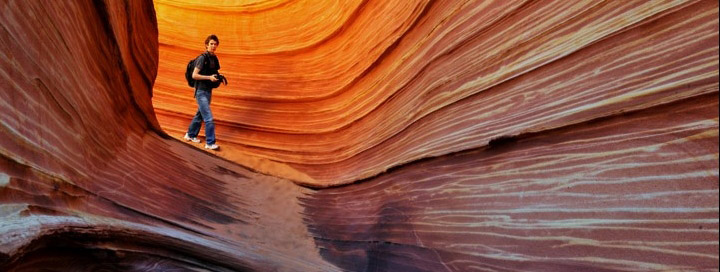
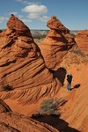
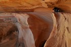
David in the Wave, Coyote Buttes North management area, southern Utah
03/13/2010 Saturday Auburn, WA to Ely, NV
We left Auburn last night around 7PM. I'd intended to pick David up at school and leave directly from there but figured we could make up a little of the time we lost by taking I-90, I-82 and I-84, then heading south from Twin Falls to Ely rather than my original plan to go through Portland, Bend, Burns Winnemucca, Carlin and Eureka mostly on secondary roads. I drove to Yakima, David to
 Pendleton while I slept, then he slept while I drove over the Blue Mountains in a snowstorm. The
car handled very well in the snow, as expected. Listening to The Known World, an audiobook I
picked up at the library, I was able to drive as far as Baker City. Around 2AM I found the Oregon
Trail agate site, along the dirt road which branches right off the gravel road which leaves OR Hwy
86 across from the OT interpretive center, but an inch of new snow obscured the agates when I went
looking for a few minutes at dawn. I slept in the back of the car, David in the passenger seat. It
was a little cramped but not too uncomfortable.
Pendleton while I slept, then he slept while I drove over the Blue Mountains in a snowstorm. The
car handled very well in the snow, as expected. Listening to The Known World, an audiobook I
picked up at the library, I was able to drive as far as Baker City. Around 2AM I found the Oregon
Trail agate site, along the dirt road which branches right off the gravel road which leaves OR Hwy
86 across from the OT interpretive center, but an inch of new snow obscured the agates when I went
looking for a few minutes at dawn. I slept in the back of the car, David in the passenger seat. It
was a little cramped but not too uncomfortable.
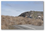 We stopped at Lime to look for the crystal site I read about some years ago but couldn't find
anything but limestone. The cement plant is closed and is deteriorating quite photogenically. I
took a few pictures; David wanted to but couldn't rouse himself from sleep. A stiff westerly breeze
was blowing so I couldn't stay out long. After Boise the wind turned fierce, scouring the landscape
for tumbleweeds and sending them stampeding across fields, vaulting fences and bounding through
freeway traffic. Some were barely larger than squirrels, others the size and color of bears, all racing before
the wind or gathering in restless piles in gullies and hollows. At Mountain Home we turned south
off the freeway to check out the big sand dune at Bruneau Dunes State Park. Dropping through the
rim rock on our descent to the Snake River we ran into a big drift of tumbleweeds stretching nearly
across the road and deep enough to bury a pickup truck.
We stopped at Lime to look for the crystal site I read about some years ago but couldn't find
anything but limestone. The cement plant is closed and is deteriorating quite photogenically. I
took a few pictures; David wanted to but couldn't rouse himself from sleep. A stiff westerly breeze
was blowing so I couldn't stay out long. After Boise the wind turned fierce, scouring the landscape
for tumbleweeds and sending them stampeding across fields, vaulting fences and bounding through
freeway traffic. Some were barely larger than squirrels, others the size and color of bears, all racing before
the wind or gathering in restless piles in gullies and hollows. At Mountain Home we turned south
off the freeway to check out the big sand dune at Bruneau Dunes State Park. Dropping through the
rim rock on our descent to the Snake River we ran into a big drift of tumbleweeds stretching nearly
across the road and deep enough to bury a pickup truck.
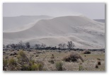
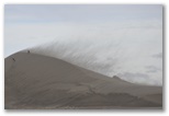
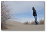 I was pleasantly surprised to find that Bruneau Dunes is a natural area where ORV's are prohibited.
The wind was raking sand off the top of the dunes in a gritty brown curtain, very impressive and
certain death to exposed cameras. We took a few furtive photos and hiked to the crest of the big
one where wind-blown sand blasted our pants cuffs. I didn't take time to identify the windswept
ducks on the lake but did notice a Northern Harrier working the brushy drainage west of the dune.
It's a place I'd like to visit again in more favorable conditions, particularly during spring
migration.
I was pleasantly surprised to find that Bruneau Dunes is a natural area where ORV's are prohibited.
The wind was raking sand off the top of the dunes in a gritty brown curtain, very impressive and
certain death to exposed cameras. We took a few furtive photos and hiked to the crest of the big
one where wind-blown sand blasted our pants cuffs. I didn't take time to identify the windswept
ducks on the lake but did notice a Northern Harrier working the brushy drainage west of the dune.
It's a place I'd like to visit again in more favorable conditions, particularly during spring
migration.
 On our way east to Twin Falls we reached Susan on the phone. I described the wind, the big dune, the dusty yellow clouds and the herds of tumbleweed
and she enjoyed picturing the scene. Heading south on US 93 into Nevada we found ourselves pursuing
a snowstorm which like a mirage kept fading away ahead of us leaving bright snowy hills under a
windy blue sky with cold sunlight streaming in from the west. We eventually caught up to a little
snow around dusk just north of Ely but the main event had passed through earlier in the day leaving
several inches in town with drifts up to a foot deep around the parking lot of the Rustic Inn, a
humble but comfortable (poor but honest...) little place I found in the yellow pages. The
proprietor recommended La Fiesta for Mexican food so we went there and spent $25 on too much dinner
after checking in to our $50 motel.
On our way east to Twin Falls we reached Susan on the phone. I described the wind, the big dune, the dusty yellow clouds and the herds of tumbleweed
and she enjoyed picturing the scene. Heading south on US 93 into Nevada we found ourselves pursuing
a snowstorm which like a mirage kept fading away ahead of us leaving bright snowy hills under a
windy blue sky with cold sunlight streaming in from the west. We eventually caught up to a little
snow around dusk just north of Ely but the main event had passed through earlier in the day leaving
several inches in town with drifts up to a foot deep around the parking lot of the Rustic Inn, a
humble but comfortable (poor but honest...) little place I found in the yellow pages. The
proprietor recommended La Fiesta for Mexican food so we went there and spent $25 on too much dinner
after checking in to our $50 motel.
We left Auburn last night around 7PM. I'd intended to pick David up at school and leave directly from there but figured we could make up a little of the time we lost by taking I-90, I-82 and I-84, then heading south from Twin Falls to Ely rather than my original plan to go through Portland, Bend, Burns Winnemucca, Carlin and Eureka mostly on secondary roads. I drove to Yakima, David to
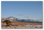
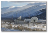
At the Lehman Cave Visitor's Center the ranger was just putting up the flag when we arrived. I was not inclined to believe him at first when he told me they were on Pacific Time and we were an hour early for our cave tour, but that did explain why the clock at the motel in Ely had been an hour slow. We used our extra hour to eat a leisurely breakfast in the sunshine in front of the visitor's center where the snowbanks were just receding from the front lawn and the only clouds in the deep blue sky were hovering over snowy mountains on the horizon 100 miles to the east.
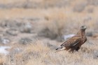
Dark phase Ferruginous Hawk
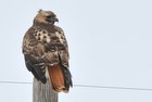
Red-tailed Hawk
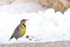
Western Meadowlark
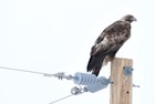
Golden Eagle
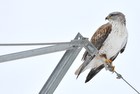
Light phase Ferruginous Hawk
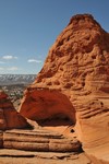
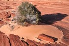
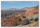
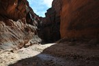
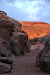
South of Panguitch we finally began to leave the storm behind us but the snowpack continued to increase until we reached the pass north of the turnoff to Zion, 3-4 feet up there and crusty snowfields lingering on shady slopes all the way down to where we stopped for the night, about 7 miles north of Kanab. There we found the ORV track off the east end of the old road and followed it about a third of a mile in before the sand became too soft. We found a campsite there and though it was nearly 6PM, set off to the north across bright orange sand dunes stabilized with juniper, rabbitbrush, oaks and scattered Ponderosa pines. Our objective was Peekaboo canyon, aka Red canyon, a small but colorful slot which runs east-west along the north edge of the dunes. When we hadn't reached the wash in 45 minutes I realized we wouldn't make it so we turned back, reaching the car right at sunset. The evening was cold and breezy so we ate supper in the car, more of the delicious lasagna Susan had sent with us. Thanks to her provisioning and a couple of meals out, we never did have to fire up the stove the whole trip. That was a big help, giving us that much more time to spend out hiking around taking pictures.
Frosty morning with dawn around 6:45 Mountain Daylight Time. We packed up quickly and drove to the Pariah ranger station where we ate breakfast while waiting for the doors to open. About 10 groups were applying for Coyote Buttes North permits; we were assigned number six. At 9:05AM a volunteer ranger spun the wire cage and the first ball she pulled out was #6, so once again, we were in. I thanked Jesus because I'd been talking with him during the night about how I'd been mistaken about the timezone, even though I'd been convinced that I was right, and how I might also be mistaken in my conviction that I'm not saved. Evidently I'm not always correct in my beliefs, and Jesus might be able to do something with that.
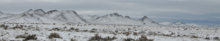
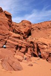
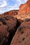
The 18.5 mile drive from hwy 89 to the Paw Hole trailhead for Coyote Buttes South was tough. The first 10 miles to the Arizona state line (2 miles past the Wire Pass trailhead) were deeply rutted and often rocky, though fortunately the dirt was hard-packed and only slippery in a few places. The last 2 1/2 miles of soft orange sand after the turn-off to Paw Hole would probably would have been impassable for us were it not firmed up by underlying moisture from winter snow, patches of which still lingered on shady corners.
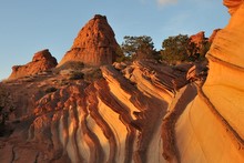
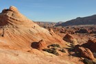
Paw Hole teepees
Orange hollow
Shaded wall
Tough descent
Lunch cave
Lichen wall
Fins
We drove out from Paw Hole at dusk intending to camp at Stateline but we failed to notice the turnoff in the dark so ended up spending the night in the parking lot at Wire Pass. On the way I forgot to stop at a snowbank to replenish the cooler so we unpacked all our food and chilled it overnight in the frost on top of the car. Coyotes serenaded us sometime during the night and at 5:30AM a big pickup roaring by on the road woke us up. By the time the first cars pulled into the
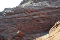
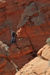
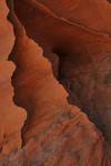
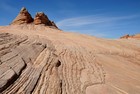
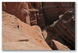
Above the two red teepees that the BLM directions reference as landmarks on the way to the Wave, there's a cove enclosed on three sides by weird and wonderful sandstone textures. Daniel and I came across it two years ago on our way back to the car so I took David up there this morning on the way in. It was not far out of our way and well worth the visit.
David on teepee north of the Wave
Shrub in ledgy wash below the Wave
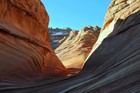
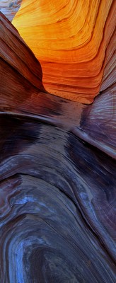
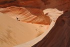
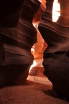
Entrance to the Wave
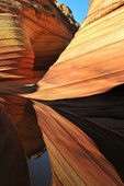
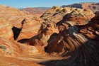
View north over the Wave

Muffins above the Wave
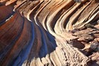
Striated sandstone above the Wave
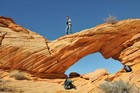
Arch on the rim above the Wave
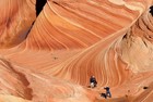
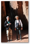
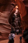
Photographers in the Wave
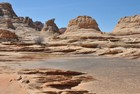
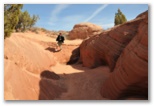
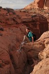
After poking around a bit above the Wave (though we missed the Second Wave a hundred meters or so west of the main event), we scrambled up the slope southwest of the wave and crossed above the crack to the arch, where we ate lunch and spied on the hikers taking photos and eating their lunches in the Wave. After lunch we explored
David in sand dune bowl
The hard way into the bowl
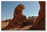
Instead we hiked generally south to the head of a big canyon that opens out to the northeast. We considered hiking down it and out towards some red teepees off in the distance but the head of the canyon was a little too steep to descend so we continued south up onto an plateau of irregular white
Top Rock teepees
Iron pellet flat
Dinosaur tracks
Crossing quicksand
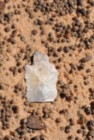
Agate arrowhead
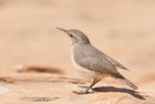
Rock Wren
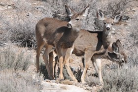
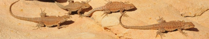
Not much wildlife today either - a black bovine along the trail on the way in, several Side-blotched Lizards, Ravens, the Golden Eagle, the possible Peregrine, several Rock Wrens, a pair of Titmice in a bush above the crack (and slightly too furtive for photos) and a flock of Pinon Jays somewhere out there.
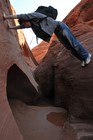
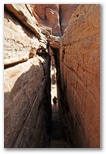
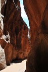
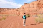
David in Buckskin Gulch (standing on truck tire)
On the way out from Wire Pass, about two miles from hwy 89, we turned right on a side road and found a flat spot to camp about a quarter mile up. Overnight we hung David's pack and clothing on bushes around camp hoping the odor imparted to them yesterday by his poop in a bag would dissipate. He had to go while we were in the Wave and there was no place for it, so we used a couple of ziplock bags in which we'd been carrying our lunch. Later, up on top, I found a somewhat weathered purple fleece pullover and we wrapped the bags in that, but to David's dismay the odor still managed to permeate his pack. This morning his clothes were OK but the pack wasn't quite. We stopped at the BLM ranger station to deposit the bag and I draped the poopy purple pullover on a log in the sun all day while we hiked Buckskin Gulch. It was fine, though still a little sandy, when we returned to the car at dusk.
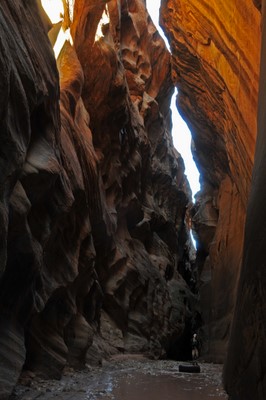
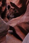
Long Canyon slot
Long Canyon slot
David running down the wash
Juniper snags
View from the rim
David descending the Middle Route
Ready for canyon hiking
The easy way down
Absorbed in exploring the canyon we forgot about lunch, then when we finally noticed that we were hungry we couldn't find a sunny spot
Last sun in the canyon
03/18/2010 Thursday Page, AZ
For today, our last full day before we had to head home, we had three locations left that I wanted to visit - Lower Antelope Canyon, Upper Antelope Canyon, and Water Holes canyon. We decided to see if we could get a permit for Water Holes first, then check out Lower Antelope and maybe Upper Antelope, then try Water Holes if we had time. We drove out to LeChee pronounced "hle-chi'ee" according to the Navajo woman at the LeChee senior center) but the Navajo parks office in the white trailer behind the pink stucco building was closed. The woman at the senior center gave us a couple of phone numbers to try but no-one answered, so we drove back to Lower Antelope Canyon.
For today, our last full day before we had to head home, we had three locations left that I wanted to visit - Lower Antelope Canyon, Upper Antelope Canyon, and Water Holes canyon. We decided to see if we could get a permit for Water Holes first, then check out Lower Antelope and maybe Upper Antelope, then try Water Holes if we had time. We drove out to LeChee pronounced "hle-chi'ee" according to the Navajo woman at the LeChee senior center) but the Navajo parks office in the white trailer behind the pink stucco building was closed. The woman at the senior center gave us a couple of phone numbers to try but no-one answered, so we drove back to Lower Antelope Canyon.
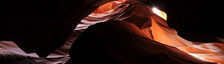
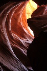
Lower Antelope Canyon Photo Gallery

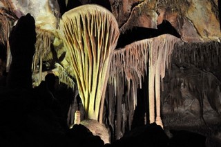
 Lower and Upper Antelope Canyons are both commercial sites on the Navajo Reservation just east of
Page along Hwy 98. From "downtown" Page take Lake Powell Blvd around to Coppermine Road then turn
left on hwy 98 at the bottom of the hill. Or drive a mile or two south of Page on hwy 89 and turn
left onto 98. Shortly after crossing the bridge over Antelope Wash and before the power
plant turn right into the parking area for Upper Antelope or left, and left again, for the parking
area for Lower Antelope. Both canyons are accessible only via guided tours which cost $25 per
person (plus a $6/person hiking permit fee) and start at the respective parking areas. Upper
Antelope requires a jeep ride up the wash so the tours are somewhat more structured, though once
in the canyon it is not difficult to "lose" your tour group. For Lower Antelope you
just walk in from the parking lot. Because I was carrying a tripod, David and I received a
"photographer's permit" for Lower Antelope which enabled us to stay in the canyon for up to 4
hours. We used 3 of them.
Lower and Upper Antelope Canyons are both commercial sites on the Navajo Reservation just east of
Page along Hwy 98. From "downtown" Page take Lake Powell Blvd around to Coppermine Road then turn
left on hwy 98 at the bottom of the hill. Or drive a mile or two south of Page on hwy 89 and turn
left onto 98. Shortly after crossing the bridge over Antelope Wash and before the power
plant turn right into the parking area for Upper Antelope or left, and left again, for the parking
area for Lower Antelope. Both canyons are accessible only via guided tours which cost $25 per
person (plus a $6/person hiking permit fee) and start at the respective parking areas. Upper
Antelope requires a jeep ride up the wash so the tours are somewhat more structured, though once
in the canyon it is not difficult to "lose" your tour group. For Lower Antelope you
just walk in from the parking lot. Because I was carrying a tripod, David and I received a
"photographer's permit" for Lower Antelope which enabled us to stay in the canyon for up to 4
hours. We used 3 of them.
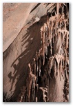
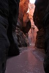
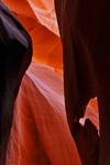
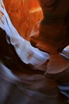
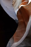
 Lower Antelope isn't much of a hike. We paid our $62 and received our photographer tags, then
followed our guide, a young Navajo man of indeterminate age down into the wash, across a ledge
with a dinosaur track in it, then into a sinuous crack about a foot wide in a flat sandstone
ledge at the apparent end of the wash. We lost the rest of our group, a family with a couple of
young kids, as soon as we stopped for photos. We came across our guide again an hour or two later and
talked with him a bit. Giving tours in Antelope Canyon is a sideline; his main job is welding
pipes for the renovation of the middle generator at the powerplant, which explained why no smoke
Lower Antelope isn't much of a hike. We paid our $62 and received our photographer tags, then
followed our guide, a young Navajo man of indeterminate age down into the wash, across a ledge
with a dinosaur track in it, then into a sinuous crack about a foot wide in a flat sandstone
ledge at the apparent end of the wash. We lost the rest of our group, a family with a couple of
young kids, as soon as we stopped for photos. We came across our guide again an hour or two later and
talked with him a bit. Giving tours in Antelope Canyon is a sideline; his main job is welding
pipes for the renovation of the middle generator at the powerplant, which explained why no smoke
 was coming out of middle stack this morning. He told us he'd worked all night and had welded 120
pipes, and in fact had been working for almost 36 hours straight, two 12-hour shifts of his own
plus another 12-hour shift in between when he'd filled in for a friend. He explained that by the
time the renovation is complete in a couple of years he hoped to have made enough money to retire.
That surprised us because we'd guessed his age at about 25. We wondered what he would do after he
retired but didn't ask. He was heading home to go to bed until his next shift began this evening.
We tipped him $10 towards his retirement, having asked another guide if tips were appropriate.
was coming out of middle stack this morning. He told us he'd worked all night and had welded 120
pipes, and in fact had been working for almost 36 hours straight, two 12-hour shifts of his own
plus another 12-hour shift in between when he'd filled in for a friend. He explained that by the
time the renovation is complete in a couple of years he hoped to have made enough money to retire.
That surprised us because we'd guessed his age at about 25. We wondered what he would do after he
retired but didn't ask. He was heading home to go to bed until his next shift began this evening.
We tipped him $10 towards his retirement, having asked another guide if tips were appropriate.
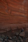
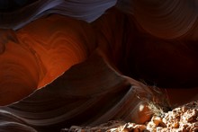
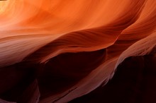
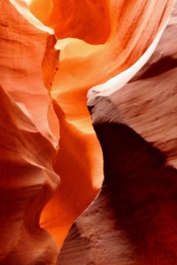
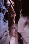
The photography was trickier than I remembered. On our previous visit I'd been using a Panasonic point-and-shoot without doing anything special with the settings. While the colors in my photos from that trip were stunning, I'd been a little frustrated with high noise levels and the inability to control depth of field.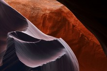 One of the big factors in my decision to buy a DSLR was my plan to return to Lower Antelope Canyon
with equipment to match the subject but once in the canyon again, I had trouble getting the settings
right on the more complicated equipment. White balance was particularly challenging - "Auto"
assumed that the shaded orange walls were neutral gray, leaving orange only in places with strong
reflected color. "Sunlight" on the other hand put everything in shades of reddish-brown, accurate
One of the big factors in my decision to buy a DSLR was my plan to return to Lower Antelope Canyon
with equipment to match the subject but once in the canyon again, I had trouble getting the settings
right on the more complicated equipment. White balance was particularly challenging - "Auto"
assumed that the shaded orange walls were neutral gray, leaving orange only in places with strong
reflected color. "Sunlight" on the other hand put everything in shades of reddish-brown, accurate
 but not nearly as beautiful as the rainbow of hues ranging from purple to yellow in the photos from
the point-and-shoot. After a while I found another photographer to compare settings with; he was
using a D3 I think, and his photos had a beautiful range of deep reds and yellows which I couldn't
seem to capture regardless of which WB setting I used. In the end I settled for switching between
"Sunlight" and "Auto" with a smattering of more exotic settings thrown in for variety. The
photographer I compared notes with was also using long exposures, achieved by stopping the lens way
down and using a very low ISO, so towards the end I tried that approach with unfortunate results.
It turns out that the 18-105 DX lens has problems with flare at high f-stops. When I shot at f18
and above with a strong highlight in or near the frame, the images were ruined by small pale circles
which increased in frequency and decreased in size as the f-stop increased. A shot which would have
no discernible flare at f11 or f13 would be littered with pale spots at f22. Unfortunately I didn't
figure out the cause of the spots until later, and as a result ruined probably a third of my photos,
particularly in the upper canyon where I used high f-stops almost exclusively. And using long
exposures didn't even seem to make much difference with color saturation either, though I need to
experiment a little more with that. The tripod and ballhead, on the other hand, were again
terrific. I could achieve any angle I wanted quickly and easily. The ballhead held the camera
perfectly stable and the quick-release meant that I could pack up and move, or re-orient the camera
from horizontal to vertical, in a flash.
but not nearly as beautiful as the rainbow of hues ranging from purple to yellow in the photos from
the point-and-shoot. After a while I found another photographer to compare settings with; he was
using a D3 I think, and his photos had a beautiful range of deep reds and yellows which I couldn't
seem to capture regardless of which WB setting I used. In the end I settled for switching between
"Sunlight" and "Auto" with a smattering of more exotic settings thrown in for variety. The
photographer I compared notes with was also using long exposures, achieved by stopping the lens way
down and using a very low ISO, so towards the end I tried that approach with unfortunate results.
It turns out that the 18-105 DX lens has problems with flare at high f-stops. When I shot at f18
and above with a strong highlight in or near the frame, the images were ruined by small pale circles
which increased in frequency and decreased in size as the f-stop increased. A shot which would have
no discernible flare at f11 or f13 would be littered with pale spots at f22. Unfortunately I didn't
figure out the cause of the spots until later, and as a result ruined probably a third of my photos,
particularly in the upper canyon where I used high f-stops almost exclusively. And using long
exposures didn't even seem to make much difference with color saturation either, though I need to
experiment a little more with that. The tripod and ballhead, on the other hand, were again
terrific. I could achieve any angle I wanted quickly and easily. The ballhead held the camera
perfectly stable and the quick-release meant that I could pack up and move, or re-orient the camera
from horizontal to vertical, in a flash.
Having found my photos from last time somewhat cluttered, I looked for simpler compositions this time. Inspecting them on the camera viewfinder I was somewhat disappointed but once I got them onto the computer, I was much happier with the results.
The photography was trickier than I remembered. On our previous visit I'd been using a Panasonic point-and-shoot without doing anything special with the settings. While the colors in my photos from that trip were stunning, I'd been a little frustrated with high noise levels and the inability to control depth of field.
Having found my photos from last time somewhat cluttered, I looked for simpler compositions this time. Inspecting them on the camera viewfinder I was somewhat disappointed but once I got them onto the computer, I was much happier with the results.
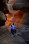
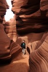
In a state of aesthetic fatigue after three hours in Lower Antelope Canyon, we drove across the street and signed up for a tour of Upper Antelope Canyon. With two couples from Texas and a young man from Norway we piled into the canopied bed of something like a pickup truck and rode up the wash with our tour guide from Antelope Canyon Navajo Tours. I recalled his name as Mike but the card he gave me says Dalvin Etsitty 928-698-3384.
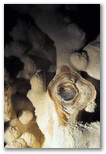
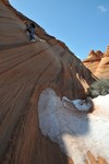
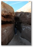
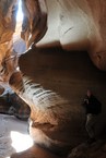
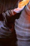
The canyon itself is more open and spacious inside and much darker than Lower Antelope. Fluted walls of dark reddish sandstone rise directly from a flat sandy floor then close in overhead allowing, during midday from spring to fall, a few beams of sunlight to reach down inside.
Upper Antelope entrance
Upper end of the canyon
Inside Upper Antelope
The entrance from inside
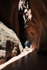
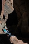
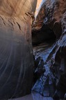
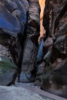
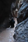
When I told our guide about our desire to hike Water Holes canyon and our lack of a permit he told us "Just go hike up it and if you see a ranger, pay him the permit fee." That sounded good to us so we drove down there, following 89 west past Page to 98, then south a few miles to park on the left side just north of the bridge. The parking area was fenced and gated with a big weathered sign which stated "Entry without permission is a violation of tribal and federal law" or some such thing. Moreover the gate was padlocked, but the lock was open and several cars were already parked inside, so we opened the gate and pulled in too. I checked the windshields of the other cars, at least one of which was from out of state, and saw no permits so I figured we wouldn't attract any attention. Not until we were hiking back down the canyon around sunset did it occur to me that we would be the last ones out, and we might find the gate locked with our car inside, or worse, with our car towed away. I prayed about that but didn't share my worry with David. He'd find out soon enough.
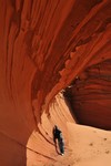
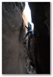
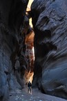
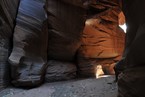
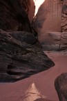
In the wash
Sinuous section
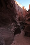
Near the entrance
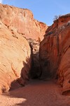
Lower entrance to slot
Deeper section

Subdued colors
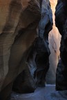
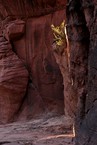
The first slot opened up into a wash again but after about a quarter mile we came to a dry pothole falls about 10 feet high. David managed to scramble around above it but I didn't quite dare follow him. By hiking up around to the left there was a place to drop into the canyon above the falls but it too was steeper than I wanted to tackle late in the day. David scrambled out that way after exploring a short ways up one of the branches. The right branch is apparently the one to take; it extends for some distance and is very narrow in places, according to The American Southwest website.
On the way out we hiked along the rim of the upper slot canyon section. That was a little spooky; from above the slot is a black crevasse in the weathered sandstone, narrow enough to jump across in many places though I didn't dare try. Just thinking about still tweaks my innards. David was bold enough to sit on a point of rock over the chasm; the photo doesn't manage to convey how
Slot from above
David perched over chasm
Approaching sunset
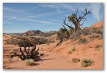
Mountain Mahogany
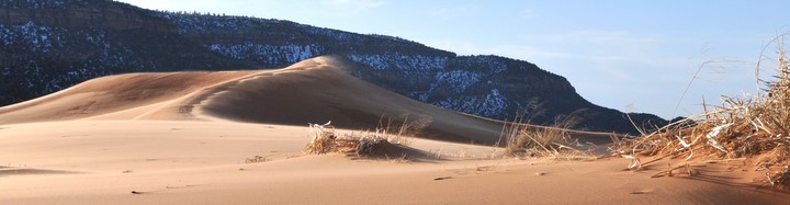
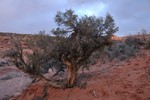
Though I would have liked to stay another night and hike back up Water Holes canyon, that trip really needs a full day and we'd have had to leave by early afternoon, and then drive 24 hours straight to get back in time for the CWA charity auction Saturday evening, so instead we started home. We didn't even stop at a Mexican restaurant in Page for supper. Instead we made camp off the road down to Coral Pink Sand Dunes state park a few miles north of Kanab. Someone has plowed a bunch of roads back into the juniper woods, apparently to cut some junipers, and we found a
Our last campsite
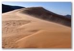
The biggest dune
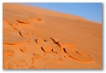
Wind-etched sand
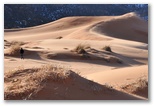
David in dunes
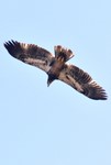
Golden Eagle
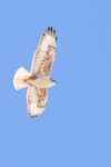
Ferruginous Hawk
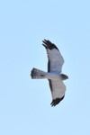
Male Northern Harrier
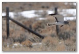
Male Northern Harrier
05/07/2010 Friday
We had an unusually late frost last night, 37F on the back porch at 7AM and frost on the shingles of the garage roof as well as all across the field. Not a problem for anything in the garden because I don't have anything planted. It was still quite chilly a couple hours later to numb my fingers when I stood out on the back porch watching Yellow-rumped and Orange-crowned warblers foraging for their breakfast in the maple tree. The Orange-crowneds arrived here the day before yesterday; the Yellow-rumps a couple of weeks ago.
We had an unusually late frost last night, 37F on the back porch at 7AM and frost on the shingles of the garage roof as well as all across the field. Not a problem for anything in the garden because I don't have anything planted. It was still quite chilly a couple hours later to numb my fingers when I stood out on the back porch watching Yellow-rumped and Orange-crowned warblers foraging for their breakfast in the maple tree. The Orange-crowneds arrived here the day before yesterday; the Yellow-rumps a couple of weeks ago.
Top Lehman Cave Coyote Buttes S Coyote Buttes N BuckskinGulch Lower Antelope Upper Antelope Water Holes Coral Pink Dunes
Brianpen Home | Journal Home | Previous | Next (2)