


Results and Photos
Official results are posted here for the Tunnel Lite Marathon held on Sunday September 14. 143 runners finished the race and 28% of them qualified for Boston.
Our race photographer Ross Comer has posted photos from the marathon here. We did not get finish line photos but Ross took photos and a video of runners at the tunnel exit.
We wish to acknowledge and thank our volunteers this year. Volunteers for either this race or the Light at the End of the Tunnel Marathon in July will receive a reserved place in the 2015 Light at the End of the Tunnel Marathon. Codes and instructions will be emailed to volunteers next spring. The 2015 race may be moved up to June next year, but in any case, registration will open in early March. Open registration will likely fill within an hour but registration for 2014 volunteers will remain open until a few weeks before race date.
About the Race
If this page looks alot like the Light at the End of the Tunnel Marathon page, it's because much of this race looks quite a bit like the Light at the End of the Tunnel Marathon in July. Same tunnel, same downhill course, still a Boston qualifier. If past history is any indication, you will be able to use the Tunnel Lite Marathon to qualify for Boston 2015 next April, as well as for Boston 2016. Open registration for Boston 2015 will begin on September 17 so unless Boston fills with runners five minutes and more under their qualifying times, you'll be able to sign up on Monday Sept 17th.
The original purpose of this race was to accomodate runners who weren't able to get into the Light at the End of the Tunnel marathon in July. Plus we had some leftover bibs and medals to use up. So if the incidentals (bibs, medals, hooplah) are important to you, run the July race. This year the Tunnel Lite again shares the same medals and bibs as the Light at the End of the Tunnel, and is similarly organized and supported. We'll again use chip timing and we'll send the results to Boston promptly. We bus runners to the start, supply drop bags for your flashlight and clothing, provide 10 aid stations along the course and keep medical personnel standing by. And did we mention, it's the same fast downhill course, so if you run the race in July and don't quite get a BQ, here's a second chance. In fact this race typically has finishing times 10 minutes faster than the July race due to cooler weather.
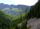
The course starts at Hyak, 50 miles east of Seattle Washington, and runs down to North Bend on gravel rail-trails. It is a Boston qualifier (USATF certification number WA 08031 MW) and has the best profile in the country for a fast time due to the consistent gentle downhill grade and the low starting elevation. The first three miles are flat, cold, foggy and damp inside an unlit tunnel. Flashlights are strongly recommended. Once out of the Tunnel the gravel trail starts down the hill and keeps on going down, 2050 feet in the next 23 miles. It's never steep enough to be uncomfortable; you just feel like you're having a good day. Spectators, other than an occasional bear, are few but the views are nice. Aid stations with water, Gatorade, and cups are provided every three to five miles (most are self-serve) and restrooms are located here and there. We provide medical support and marshals on bicycles on the course, which is supported for 6 1/2 hours (7 1/2 for the early starters). At the finish you'll find some better-than-average food and a few friendly people awaiting you.
If this page looks alot like the Light at the End of the Tunnel Marathon page, it's because much of this race looks quite a bit like the Light at the End of the Tunnel Marathon in July. Same tunnel, same downhill course, still a Boston qualifier. If past history is any indication, you will be able to use the Tunnel Lite Marathon to qualify for Boston 2015 next April, as well as for Boston 2016. Open registration for Boston 2015 will begin on September 17 so unless Boston fills with runners five minutes and more under their qualifying times, you'll be able to sign up on Monday Sept 17th.
The original purpose of this race was to accomodate runners who weren't able to get into the Light at the End of the Tunnel marathon in July. Plus we had some leftover bibs and medals to use up. So if the incidentals (bibs, medals, hooplah) are important to you, run the July race. This year the Tunnel Lite again shares the same medals and bibs as the Light at the End of the Tunnel, and is similarly organized and supported. We'll again use chip timing and we'll send the results to Boston promptly. We bus runners to the start, supply drop bags for your flashlight and clothing, provide 10 aid stations along the course and keep medical personnel standing by. And did we mention, it's the same fast downhill course, so if you run the race in July and don't quite get a BQ, here's a second chance. In fact this race typically has finishing times 10 minutes faster than the July race due to cooler weather.
The course starts at Hyak, 50 miles east of Seattle Washington, and runs down to North Bend on gravel rail-trails. It is a Boston qualifier (USATF certification number WA 08031 MW) and has the best profile in the country for a fast time due to the consistent gentle downhill grade and the low starting elevation. The first three miles are flat, cold, foggy and damp inside an unlit tunnel. Flashlights are strongly recommended. Once out of the Tunnel the gravel trail starts down the hill and keeps on going down, 2050 feet in the next 23 miles. It's never steep enough to be uncomfortable; you just feel like you're having a good day. Spectators, other than an occasional bear, are few but the views are nice. Aid stations with water, Gatorade, and cups are provided every three to five miles (most are self-serve) and restrooms are located here and there. We provide medical support and marshals on bicycles on the course, which is supported for 6 1/2 hours (7 1/2 for the early starters). At the finish you'll find some better-than-average food and a few friendly people awaiting you.
Race dayreturn to top
There is no pre-race Expo. Runner check-in is at the start. Most runners will want to park at the finish and catch one of the free buses to the start. Conditions at the start will be cool and possibly wet, so bring extra clothing to keep warm. At check-in you'll receive two drop bags with your bib number marked on them. One drop bag is for you to leave at the start with your warm clothing. You should carry the other drop bag through the tunnel and leave it at the aid station with your flashlight and any additional clothing you want to leave behind (the tunnel is cool and somewhat damp as well as dark). Volunteers will collect your drop bags and transport them to the finish for you.
Your family is welcome to join you at the start or along the course but a $10 Discover Pass parking permit is required. It may be purchased at the parking area at the start, or in advance of race day online here. Here are directions to spectator course access points. Note that the Discover Pass requirement is enforced; cars without Discover Passes at the start in July were ticketed.
Family members on bicycles can ride down the trail during the race but should not bicycle through the tunnel with the runners due to crowding. Spectators should note that providing assistance to runners during the race is not allowed, except for race officials and aid station volunteers. If your family or friends want to bike the course but do not want to leave a car at the start, you may be able to find a volunteer to either drive you and your bikes up to the start, or to drive your car back to the finish for you. Buses are for runners only and are generally not be able to transport bicycles for spectators/family members.
Here's the race day schedule:
5:00AM
Parking area at Twin Falls Middle School opens.
5:30AM
Bus for early starters leaves parking area
5:40-6:40AM
Buses for regular starters leave parking area
6:00-6:45AM
Early starters check in and prepare to run
6:30-7:15AM
Regular starters check in and prepare to run
7:00AM
Early start
8:00M
Regular start
10:30AM
Finish area opens
10:45AM-2:30PM
Buses shuttle runners back to parking areas
11:00AM
Garcia (13 mile) aid station closes
11:45AM
Twin Falls (16 mile) aid station closes
1:15PM
Rattlesnake (21 mile) aid station closes
2:30PM
Official timing closes. Finish area takedown begins.
Last runner in
Skeleton finish area crew wraps up.
We don't offer a pre-race pasta feed but the North Bend Grill is popular and there are lots of other nice restaurants within
a half hour drive towards Seattle. For a fancy dinner, try the Salish Lodge a few miles north of North Bend in Fall City.
Parking at the Start
Some runners, particularly those driving from east of the mountains or staying at Snoqualmie Pass, may prefer to park at the start. If we know in advance we will attempt to arrange for transportation back to the start from the finish so if you are considering parking at the start, please notify the race director. In the past we have not had anyone stuck at the finish.
Please note that a Washington State Discover Pass is required to park at the start. Day parking passes are available at a self-service fee station at the start parking area and cost $10. They are also available online. If you park without a Discover Pass at the start even for only half an hour or so, you stand a good chance of getting a $99 ticket; cars without Discover Passes at the start in July were ticketed.
The Marathon Coursereturn to top
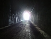
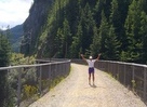
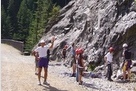
The race starts at the Hyak trailhead for the John Wayne Pioneer trail just east of Snoqualmie Pass. After a half mile warm-up the next 2 1/4 miles of the course run underground through the damp and pitch-black Hyak Tunnel, a little like Seattle in November only alot darker. Flashlights are strongly recommended. Once you get about 50 yards into the tunnel, you can see a pinpoint of light ahead of you which is the "Light at the End of the Tunnel" over 2 miles away. If you see more than one point of light, you're probably looking at mountain bike headlights.
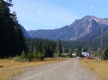
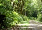
The next 13 miles run parallel to and a little above I-90 along the John Wayne Pioneer Trail, passing through a snowshed and over four high trestle bridges before diverging from I-90 and traversing mostly forested slopes for 5 more miles to the Iron Horse State Park trailhead at Rattlesnake Lake. At Rattlesnake Lake the course continues on the Snoqualmie Valley trail past a few houses and through leafy second-growth forest before returning to civilization for the last half mile or so. The race finishes at a gravel parking area along North Bend Way 2.4 miles SE of downtown North Bend.
Here's a map of the course.
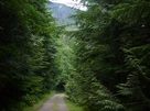
The last 23 miles of the course are all downhill at a fast 80'/mile gradient except for one little 50-yard hill at about mile 8.5 and a few short flat sections. Both the John Wayne Pioneer and Snoqualmie Valley trails are old railway grades surfaced with hard-packed gravel and wide enough for a car to pass. The surface is generally smooth but there are sections with small rocks so you'll want to watch your footing. As trail runs go, it's non-technical. Most runners will be comfortable running in road shoes but perhaps not in FiveFingers. The race director would run it in lightweight trainers if he wasn't otherwise occupied on race day. You might find gaitors helpful (see Suggestions below).
The course will not be closed to other users so expect scattered cyclists, walkers and joggers, particularly on the second half of the course, as well as rock climbers around mile 16. There should be no motorized vehicles on any portion of the course except at the two low-traffic road crossings at miles 13 and 25.5.
The course will be marked with orange tape and white-flour arrows where necessary. Every mile will be marked and numbered.
Note:
If you are nervous about heights or being inside caves, you should evaluate whether or not you'll be comfortable on this course. The tunnel is about 20' wide and 30' tall but it is almost completely dark for a couple of miles. Beyond the tunnel, there are several high trestle bridges and a few other sections of the trail from which it feels like a long ways down to the ground.
The race starts at the Hyak trailhead for the John Wayne Pioneer trail just east of Snoqualmie Pass. After a half mile warm-up the next 2 1/4 miles of the course run underground through the damp and pitch-black Hyak Tunnel, a little like Seattle in November only alot darker. Flashlights are strongly recommended. Once you get about 50 yards into the tunnel, you can see a pinpoint of light ahead of you which is the "Light at the End of the Tunnel" over 2 miles away. If you see more than one point of light, you're probably looking at mountain bike headlights.
The next 13 miles run parallel to and a little above I-90 along the John Wayne Pioneer Trail, passing through a snowshed and over four high trestle bridges before diverging from I-90 and traversing mostly forested slopes for 5 more miles to the Iron Horse State Park trailhead at Rattlesnake Lake. At Rattlesnake Lake the course continues on the Snoqualmie Valley trail past a few houses and through leafy second-growth forest before returning to civilization for the last half mile or so. The race finishes at a gravel parking area along North Bend Way 2.4 miles SE of downtown North Bend.
Here's a map of the course.
The last 23 miles of the course are all downhill at a fast 80'/mile gradient except for one little 50-yard hill at about mile 8.5 and a few short flat sections. Both the John Wayne Pioneer and Snoqualmie Valley trails are old railway grades surfaced with hard-packed gravel and wide enough for a car to pass. The surface is generally smooth but there are sections with small rocks so you'll want to watch your footing. As trail runs go, it's non-technical. Most runners will be comfortable running in road shoes but perhaps not in FiveFingers. The race director would run it in lightweight trainers if he wasn't otherwise occupied on race day. You might find gaitors helpful (see Suggestions below).
The course will not be closed to other users so expect scattered cyclists, walkers and joggers, particularly on the second half of the course, as well as rock climbers around mile 16. There should be no motorized vehicles on any portion of the course except at the two low-traffic road crossings at miles 13 and 25.5.
The course will be marked with orange tape and white-flour arrows where necessary. Every mile will be marked and numbered.
Note:
If you are nervous about heights or being inside caves, you should evaluate whether or not you'll be comfortable on this course. The tunnel is about 20' wide and 30' tall but it is almost completely dark for a couple of miles. Beyond the tunnel, there are several high trestle bridges and a few other sections of the trail from which it feels like a long ways down to the ground.
Course Map (Adapted from The Backcountry Unicyclist)
Here is a rather large topographic map of the entire course.
Here is a rather large topographic map of the entire course.
Supportreturn to top
The Tunnel Lite Marathon is a trail marathon with limited access to roads and aid along the course. You may want to carry a small water bottle, particularly if the weather is warm. You may also want to carry a cell phone.
There are porta-potties and restrooms at the start and porta-potties at the finish. Along the course there are restrooms at miles 3, 8.7, 11.6 and at mile 21.2.
We'll provide fluids and better-than-average race food at the finish.
All finishers receive a Light at the End of the Tunnel Marathon medal (your second one, if you ran the race in July), but we don't have any winners' awards for this race.
The Tunnel Lite Marathon is a trail marathon with limited access to roads and aid along the course. You may want to carry a small water bottle, particularly if the weather is warm. You may also want to carry a cell phone.
There are 9 aid stations along the course, situated at roughly 2.5 mile intervals. Water and Gatorade
are in 5 and 7 gallon plastic jugs. Cups are provided at all aid stations but at the unstaffed aid stations
you'll need to fill the cup yourself. Wastebaskets are provided at and shortly after each aid station
for cups and other litter. Runners have in the past left the trail very clean; we haven't found much
litter at all along the trail after the race. First aid supplies, provided at some of the aid stations,
include Vaseline, Band aids, salt caps, sunburn cream and bug spray.
Here are the aid station details:
In addition to the aid stations, several course marshals will be riding bicycles on the course
during the run. Course marshals will be carrying minor first aid supplies as well as a few extra GU
and will have cell phones to call for help should you need it. At least one EMT will be on the
course at all times as well, with the ability to call for assistance or emergency evacuation from
any point on the trail if needed.Here are the aid station details:
Mile
Name
Staffed
Supplies
Access
2.6
Tunnel exit
Yes
Water, Gatorade
Bike or walk. Vehicle for drop bags.
5.3
Humpback
Yes
Water, Gatorade, First aid
Bike down from start
8.0
Bandera
Yes
Water, Gatorade, GU/Roctane, First aid
Bike down from start or run/walk up from Garcia
10.7
Rock Creek
Yes
Water, Gatorade
Bike down from start or run/walk up from Garcia
13.4
Garcia
Yes
Water, Gatorade, GU/Roctane, First aid
Vehicle via Garcia Road
16.4
Twin Falls
Yes
Water, Gatorade, GU/Roctane, First aid
1/4 mile hike up Twin Falls Road
18.8
Cedar Butte
Yes
Water, Gatorade, First aid
Bike/run/walk up from Cedar Falls trailhead
21.2
Rattlesnake
Yes
Water, Gatorade, GU/Roctane, First aid
Vehicle at Cedar Falls Trailhead
22.8
Edgwick 1
Yes
Water, Gatorade, GU/Roctane, First aid
Bike/run/walk up from finish or down from Rattlesnake Lake
24.5
Edgwick 2
Yes
Water, Gatorade, GU/Roctane, First aid
Bike/run/walk up from finish
There are porta-potties and restrooms at the start and porta-potties at the finish. Along the course there are restrooms at miles 3, 8.7, 11.6 and at mile 21.2.
We'll provide fluids and better-than-average race food at the finish.
All finishers receive a Light at the End of the Tunnel Marathon medal (your second one, if you ran the race in July), but we don't have any winners' awards for this race.
Accomodationsreturn to top
Lodging and restaurants are available in North Bend within a few miles of the marathon parking, bus pickup and finish areas. The two or three closest motels have mixed reviews, though I haven't heard any complaints from our runners. The North Bend Motel (425) 888-1121 ($60-74/room night, 2.3 miles from the finish) is within a mile or so of restaurants in downtown North Bend. The Edgewick Inn (425) 888-9000 ($65-85/room night, 1.5 mi from the finish) is located at I-90 exit 34 about four miles from downtown North Bend. You'll also find a few B&B's in the North Bend area, including The Old Hen with three rooms ($125-250, 2.7 miles from the finish area) and the Roaring River B&B with four rooms ($145-195, 4.2 miles from the finish area) and the The Log Cabin with two rooms ($125-150, 3.6 miles from the finish area).
There are more motels in the Eastgate area of Bellevue along I-90 just east of I-405, which is about a 20 minute drive from the finish. There are also several motels at Snoqualmie Pass, which is a mile or two from the start and about 20 minutes from the finish.
There are two National Forest campgrounds within about 10 miles of the finish area - Tinkham and Middle Fork Campground. Go to this site and search for campgrounds near "98045". RV and tent camping are also available at the private Snoqualmie River RV Park and Campground in nearby Fall City, also about 10 miles from the finish area.
Directions to Race Parkingreturn to top
The address of the Race Parking areas at the Twin Falls Middle School is 46910 SE Middle Fork Rd, North Bend, WA 98045. Parking is available both at the school and at the Terex visitor parking lot across the street. Buses will pick up the runners in the bus pick-up area adjacent to the school parking lot and directly across the street from the Terex visitor parking lot entrance.
North Bend is about 30 miles east of Seattle on I-90 and the race parking areas are a few miles east of downtown North Bend, Washington. To get there from Seattle head east on I-90 to exit 34. At the end of the exit ramp turn left (NORTH) onto 468th Ave SE. Go about 0.6 miles and turn sharp RIGHT onto SE Middle Fork Road. The school parking lot is on the left in less than a quarter mile. The additional parking area in the Terex visitor parking is less than 100 yards up the road on the right.
Most runners will want to park in the race parking areas and ride one of the buses to the start, in part because parking at the start requires a $10 daily Discover Pass. Regular (8:00AM) starters should plan to be at the parking area between 5:30AM and 6:40AM. Buses will leave the parking area for the start between 5:30AM and 6:40AM. Runners doing the early start at 7:00AM should arrive at the parking area between 5:00AM and 5:25AM; the early start bus(es) will leave the finish area at 5:30AM.
Directions to the Finishreturn to top
The google maps address of the Finish is 44655 SE North Bend Way, North Bend WA 98045. To get there from Seattle head east on I-90 to exit 32. At the end of the exit ramp turn LEFT (North towards Mt Si) onto 436th Ave SE. Go about 0.6 miles and turn sharp RIGHT on North Bend Way. In 0.6 miles you'll see a gravel pull-off on the right where SE Tanner Road meets SE North Bend Way. That's the finish area.
To get to the race parking areas from the finish, continue east on SE North Bend Way. Just past Ole Cedar Mill Mini Storage, turn left onto SE 140th Street. Continue 1.1 miles and turn left onto SE Middle Fork Rd. The parking areas will be on the left and right in less than a quarter mile.
If you are planning to be at the finish for more than a few minutes, please park in the gravel lot inside the gate and to the left at the Ole Cedar Mill Mini Storage, which is just east and across the street from the finish area at 44800 SE North Bend Way
Directions to the Startreturn to top
To use Google maps for directions, the address at the Start is Hyak Parking Lot, Hyak, Snoqualmie Pass, WA 98068.
Head east on I-90 to Exit 54 which is two miles past Snoqualmie Summit. At the end of the exit ramp turn RIGHT then immediately turn LEFT on a road that parallels I-90 heading East. Go about 0.4 miles then you'll have to turn RIGHT at a Department of Transportation maintenance yard. After about 50 yards you'll turn RIGHT again at the first road off to the right. Follow this road 0.1 miles to the Hyak trailhead parking lot. Park at the east end of the lot.
You'll also see small brown signs with white lettering directing you from the highway offramp to the Iron Horse State Park trailhead. If you end up at Hyak Lodge or at Keechelus Lake you have missed the right turn heading to the Hyak parking lot. This aerial photo shows the start area - follow the orange line.
A daily ($10) or annual ($30) Discover Pass is required to park at the start area. Overnight parking at the start is not permitted, although there are areas nearby where an RV could probably be parked overnight.
If you plan to park at the start, you should arrive before 7:30AM (6:30AM for early starters) to allow time to pick up your packet and prepare to run.
Suggestionsreturn to top
Gaitors - You may want running gaitors to keep gravel out of your shoes. The rae director has been known to use Dirty Girl Gaitors and finds that they work well.
Flashlight - It is possible to run the tunnel without a light, but you'll probably want one. We'll give you a drop bag to leave at the end of the tunnel so you don't have to carry your light the rest of the way.
Don't go barefoot - While you may be a fan of barefoot running, this might not be the course for minimalist shoes. Two years ago we had to run up the trail with a pair of shoes to rescue a runner in Five-fingers. If you do plan to use lightweight shoes, make sure you've trained in them on gravel roads. That said, the race director runs the course in racing flats.
Downhill training - Add some downhill running to your training. Long gentle downhill at a brisk pace would be best but any runnable downhill grade will work. Do repeats if your hills are short. Your quads will thank you.
Sunscreen and Bug Dope - We'll have these at the start for you and you may want to use them. You'll also find sunscreen at several of the aid stations. You'll get some sun in the middle half of the course and at the finish but overall the course is mostly shaded. Mosquitos are unlikely this time of year but you may find a couple, particularly if you take walk breaks, in some of the wooded sections in the second half.
Start Early if you need more than 6 or 7 hours to complete the race you should consider starting early. The course closes at 2:30PM so starting at 7AM gives slower runners and walkers 7 1/2 hours to finish. Runners who expect to finish in under 5 hours should start at the regular time since since a minimum official finishing time of 5:00:00 will assigned to early starters who come in under 5 hours.
Weatherreturn to top
Typical weather on race day is cloudy and 45F at the start and partly sunny warming to the mid 60's at the finish. Highs could reach the low 80's but on the other hand, steady cold rain is also a possibility. We'll provide an updated forecast as race day approaches and all runners should take the weather into account. Out on the course, you could be a long walk from shelter. Temperature in the tunnel is a constant 50F or so with dripping water in places and even a little fog at times. Though there are sunny sections on the rest of the course, this time of year much of it is in the shade and air temperatures seem to stay cooler than the thermometer might indicate. The last 6 miles are mostly through shady forest which helps if the weather is warm.
Typical weather on race day is cloudy and 45F at the start and partly sunny warming to the mid 60's at the finish. Highs could reach the low 80's but on the other hand, steady cold rain is also a possibility. We'll provide an updated forecast as race day approaches and all runners should take the weather into account. Out on the course, you could be a long walk from shelter. Temperature in the tunnel is a constant 50F or so with dripping water in places and even a little fog at times. Though there are sunny sections on the rest of the course, this time of year much of it is in the shade and air temperatures seem to stay cooler than the thermometer might indicate. The last 6 miles are mostly through shady forest which helps if the weather is warm.