Brian's Journal - Spring Break 2008
Journal Home | Previous | Next (12) Mt Wilson | Antelope Cyn | Water Holes Cyn | Buckskin Gulch | Coyote ButtesJournal of hiking in the southwest with Daniel over his spring break
3/16/2008 To Las Vegas NV
I didn't allow enough time for packing.
I was busy with other tasks - researching where to go, finishing up some work that I hadn't had time to do on Friday. Daniel had all his things neatly laid out on the floor while I ran around grabbing clothes and gear. Then we discovered we couldn't fit it all in the suitcases and it was already 20 minutes after we should have left and I hadn't packed any food yet. We found larger suitcases, threw our stuff in them and made it to the plane in time but I forgot to include the food I had bought the day before just for the trip.
The plane was full as they usually are these days. We couldn't sit together but both of our seats were in the very last row. Daniel had a middle seat but he was the first in his row to show up so he slid over to the window seat. The older couple who arrived a few minutes later didn't seem to notice or mind. The weather was stormy most of the way down so he didn't see much although he did catch a glimpse of Mount Wilson, its crags shrouded in gray clouds, as we descended to land.
We found the Gold Coast Casino easily then drove around another 20 minutes or so in our big white Dodge Durango looking for a grocery store or a place to eat. Nothing looked suitable so we returned to the casino and checked in. Our room was at the far end of a very long hallway with carpet soft enough to hinder the rolling of our suitcases. The furnishings were sparse but serviceable, the room quiet and the bed comfortable enough. We ate out at Ricardo's, mentioned but not recommended by the bell desk downstairs. Daniel ordered a veggie enchilada and received instead a fajita with nicely steamed vegetables but not much flavor. My halibut in red sauce wasn't bad. I wasn't hungry but ate all of it anyhow. Highlight of the meal was a quiet man in a sports coat and tie who made his way from table to table performing magic tricks with deft movements and a hint of a smile. He caused red fabric balls to multiply in a little girl's hand at the table next to us then pulled gold coins out of the air next to her ear. At our table he caused wooden balls to drop through the solid bottom of a metal cup, then pushed a crayon through the same cup. We didn't even try to figure out how he did it, and were so amazed we didn't think to give him a tip.
We stayed up way too late reading. I nearly finished The Tenderness of Wolves and Daniel made it much of the way through A Thousand Splendid Suns. For the rest of the trip I promised myself I would eat less and sleep more, but being in Las Vegas for the night, we splurged and stayed up late.
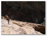
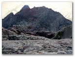
3/17/2008 Mount Wilson, Las Vegas NV. 8 miles, 3700’ sunny, 50-65, light N breeze
Photo gallery of our Mount Wilson hike
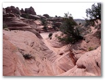
Delayed by grocery shopping and a fruitless visit to the local climbing store in search of canyoneering info, we didn't start up Mt Wilson until 11AM. At the trailhead we ate a bag of granola and half of the giant Mexican papaya we'd bought at Sunflower Market a natural foods grocery near the casino. We fixed sandwiches of hummous, broccoli sprouts, cilantro and tomatoes and set out on the trail to First Creek.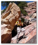
 The air was clear and the sky deep blue. Despite yesterday's storms the new snow line was a couple
thousand feet higher than Mount Wilson and the other sandstone peaks of Red Rocks. The trail up
First Creek was easier to follow but the boulders in the stream harder to negotiate than I
remembered from seven years ago. I think we took about an hour and a half to reach the narrow
embayment which cuts back to the right and provides the only access route up to the SW face of Mt
Wilson - via the crux of the hike, a 25' 5.6 crack.
The air was clear and the sky deep blue. Despite yesterday's storms the new snow line was a couple
thousand feet higher than Mount Wilson and the other sandstone peaks of Red Rocks. The trail up
First Creek was easier to follow but the boulders in the stream harder to negotiate than I
remembered from seven years ago. I think we took about an hour and a half to reach the narrow
embayment which cuts back to the right and provides the only access route up to the SW face of Mt
Wilson - via the crux of the hike, a 25' 5.6 crack.
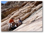
Daniel climbed it first, calling out each hand and foot hold as he found them. He didn't make it look easy but within a couple of minutes he climbed out on top and it was my turn. I determined to focus on the holds and not think about the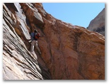 consequences of a fall, making sure that always had three solid points of contact with the rock so
 that if I lost one, I still wouldn't fall. Once on the crack I found the holds to be secure and I
was not longer anxious, just focused. It felt exhilirating to join Daniel on the gently sloping
sandstone ledges above the crack. From there the route still wasn't easy. We encountered several
sections of steep and sometimes exposed slickrock and had to gingerly downclimb out of several dead
ends as well. At the steep waterfall (dry last time but now wet with a trickle of frigid water) at
the bottom of the bowl we downclimbed one pitch then scrambled up an exposed class 3 rib, about 40',
to reach the shelf of rubble and bushes which traverses above the falls on the right. That was the
that if I lost one, I still wouldn't fall. Once on the crack I found the holds to be secure and I
was not longer anxious, just focused. It felt exhilirating to join Daniel on the gently sloping
sandstone ledges above the crack. From there the route still wasn't easy. We encountered several
sections of steep and sometimes exposed slickrock and had to gingerly downclimb out of several dead
ends as well. At the steep waterfall (dry last time but now wet with a trickle of frigid water) at
the bottom of the bowl we downclimbed one pitch then scrambled up an exposed class 3 rib, about 40',
to reach the shelf of rubble and bushes which traverses above the falls on the right. That was the
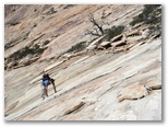
 second tough pitch. We ate lunch in a sunny furrow above and to the left of the falls then worked
too far to the left and had to drop back down 150' to find the route up the center. A cairn just
above the most difficult stretch of that route, a short but rather steeply slanted traverse,
confirmed our suspicion that we'd again found the only non-technical route up. Above that point
there were no more difficult passages. Daniel was getting tired so we slowed down a little and
reached the rim around 3:30. The drop off the east face is breathtaking. We took photos, scared
ourselves peering over the edge, worked our way up along the rim then down a snowy slope to the
final little notch before the summit. Lingering on top for a while, we called Susan over a tenuous
cellphone connection, ate an orange, wished we had wings to glide back down to the car visible 3500'
below us and two miles away by air, five by foot.
second tough pitch. We ate lunch in a sunny furrow above and to the left of the falls then worked
too far to the left and had to drop back down 150' to find the route up the center. A cairn just
above the most difficult stretch of that route, a short but rather steeply slanted traverse,
confirmed our suspicion that we'd again found the only non-technical route up. Above that point
there were no more difficult passages. Daniel was getting tired so we slowed down a little and
reached the rim around 3:30. The drop off the east face is breathtaking. We took photos, scared
ourselves peering over the edge, worked our way up along the rim then down a snowy slope to the
final little notch before the summit. Lingering on top for a while, we called Susan over a tenuous
cellphone connection, ate an orange, wished we had wings to glide back down to the car visible 3500'
below us and two miles away by air, five by foot.
 Despite fatiguing quads and sore toes and all the boulders in First Creek, we made good time on the
descent. There were still a few scary spots, particularly one 15' drop down a hole through a pile
of big boulders. By that point my nerves were feeling a little fried from the cumulative effect of
scrambling in no-fall zones but the descent down the hole turned out to be straightforward, just
three or four easy stem maneuvers. As we descended First Creek, particularly the upper section, we
marvelled at how the gravel in the streambed had been cemented together by the lime-rich water, even
turning to gray stone the clumps of moss which grew where the stream trickled down through gaps
Despite fatiguing quads and sore toes and all the boulders in First Creek, we made good time on the
descent. There were still a few scary spots, particularly one 15' drop down a hole through a pile
of big boulders. By that point my nerves were feeling a little fried from the cumulative effect of
scrambling in no-fall zones but the descent down the hole turned out to be straightforward, just
three or four easy stem maneuvers. As we descended First Creek, particularly the upper section, we
marvelled at how the gravel in the streambed had been cemented together by the lime-rich water, even
turning to gray stone the clumps of moss which grew where the stream trickled down through gaps
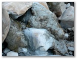
 between the boulders. Mossite. The limestone boulders were rough on our hands, weathered into
ridges and furrows sharp enough to snag clothing, but the rounded sandstone boulders in pastel
colors seemed conforting somehow, as if they would cushion our sore feet when we leaped down onto
them. As the last of the sunlit ridges out to the east yielded to the evening, chattering
white-thoated swifts escorted us out of the canyon, and canyon wrens graced the sunset with their
cascading calls. We reached the car at dusk just 2 1/2 hours from the summit.
between the boulders. Mossite. The limestone boulders were rough on our hands, weathered into
ridges and furrows sharp enough to snag clothing, but the rounded sandstone boulders in pastel
colors seemed conforting somehow, as if they would cushion our sore feet when we leaped down onto
them. As the last of the sunlit ridges out to the east yielded to the evening, chattering
white-thoated swifts escorted us out of the canyon, and canyon wrens graced the sunset with their
cascading calls. We reached the car at dusk just 2 1/2 hours from the summit.
Photo gallery of our Mount Wilson hike
Delayed by grocery shopping and a fruitless visit to the local climbing store in search of canyoneering info, we didn't start up Mt Wilson until 11AM. At the trailhead we ate a bag of granola and half of the giant Mexican papaya we'd bought at Sunflower Market a natural foods grocery near the casino. We fixed sandwiches of hummous, broccoli sprouts, cilantro and tomatoes and set out on the trail to First Creek.
Me fiddling with the camera
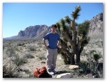
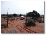
Daniel near the trailhead
Daniel climbed it first, calling out each hand and foot hold as he found them. He didn't make it look easy but within a couple of minutes he climbed out on top and it was my turn. I determined to focus on the holds and not think about the
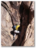
Daniel in the crack
Me in the same spot
Daniel traversing above the crack
Lunch in the bowl
Smearing up the bowl
View north from summit
View down from summit
Mossite
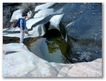
First Creek pool
3/18/2008 Mesquite NV to Page AZ sunny, 48-68
 Page wasn't our original destination today. In anticipation of camping for four days with no access
to a grocery store we spent time shopping in both Mesqute and St George: Walmart for a cooler, Ace
Hardware for stove gas since Walmart didn't carry it, another grocery store in St George for a
bigger cooler, Great Harvest for bread plus a long and helpful stop at the BLM office in St George
to peruse maps and ask about conditions. We drove through some interesting geology just east of St
George on hwy 9, first a breached anticline then a couple of cinder cones and a lava flow. I didn't
realize southern Utah had anything but sandstone. When Daniel's head cold grew worse and he began
to develop a fever, camping in the Pariah canyon area didn't sound like such a good idea so we
decided to head for Page instead, taking for variety the southern route up over the Kaibab plateau
and along the Vermilion Cliffs. I thought maybe we would see a condor but we didn't. We stopped to
eat some lunch at a rest stop high on the plateau and to take a few photos below the Vermillion
cliffs. Around dusk we passed a few interesting little towns right at the foot of the cliffs with
rustic motels interspersed with boulders perched on pedestals of shale. We reached Page well after
dark. Favorably disposed to Best Westerns after a comfortable night in Mesquite, we chose the Lake
Powell Best Western for under $70/night and Daniel went straight to bed.
Page wasn't our original destination today. In anticipation of camping for four days with no access
to a grocery store we spent time shopping in both Mesqute and St George: Walmart for a cooler, Ace
Hardware for stove gas since Walmart didn't carry it, another grocery store in St George for a
bigger cooler, Great Harvest for bread plus a long and helpful stop at the BLM office in St George
to peruse maps and ask about conditions. We drove through some interesting geology just east of St
George on hwy 9, first a breached anticline then a couple of cinder cones and a lava flow. I didn't
realize southern Utah had anything but sandstone. When Daniel's head cold grew worse and he began
to develop a fever, camping in the Pariah canyon area didn't sound like such a good idea so we
decided to head for Page instead, taking for variety the southern route up over the Kaibab plateau
and along the Vermilion Cliffs. I thought maybe we would see a condor but we didn't. We stopped to
eat some lunch at a rest stop high on the plateau and to take a few photos below the Vermillion
cliffs. Around dusk we passed a few interesting little towns right at the foot of the cliffs with
rustic motels interspersed with boulders perched on pedestals of shale. We reached Page well after
dark. Favorably disposed to Best Westerns after a comfortable night in Mesquite, we chose the Lake
Powell Best Western for under $70/night and Daniel went straight to bed.
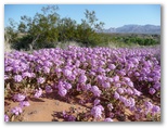
Flowers east of Mesquite
Vermilion Cliffs west of Page
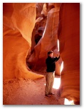
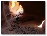
3/19/2008 Antelope and Water Holes canyons, Page AZ sunny, 42-60
Photo galleries of Lower Antelope and Water Holes canyons
 Legs a bit sore today from the Mount Wilson hike. I drove up to the Pariah BLM ranger station to
apply for a lottery permit for Coyote Buttes North since it wasn't looking like Daniel would get
better soon enough to do our planned overnight trip in Pariah Canyon. Deadline for applying for a
permit for the following day was 9AM but instead of arriving 45 minutes early, I discovered that I
was 15 minutes late due to the time change. I thought it a little odd that my watch still showed
the correct time in Page, as it had in Las Vegas, because I knew that both Utah and Arizona are on
Mountain Time. The difference is that Arizona doesn't do daylight savings so when you drive west
from Page in March you arrive in Utah an hour later than you expect to.
Legs a bit sore today from the Mount Wilson hike. I drove up to the Pariah BLM ranger station to
apply for a lottery permit for Coyote Buttes North since it wasn't looking like Daniel would get
better soon enough to do our planned overnight trip in Pariah Canyon. Deadline for applying for a
permit for the following day was 9AM but instead of arriving 45 minutes early, I discovered that I
was 15 minutes late due to the time change. I thought it a little odd that my watch still showed
the correct time in Page, as it had in Las Vegas, because I knew that both Utah and Arizona are on
Mountain Time. The difference is that Arizona doesn't do daylight savings so when you drive west
from Page in March you arrive in Utah an hour later than you expect to.
 On the way back to Page I did a little jog into the Toadstool area and took some photos of more
sandstone blocks on pedestals. Back in town I picked up a permit for Water Holes canyon from the
tribal office in Lechee - not easy to find. About 3 miles east of Lake Powell Blvd on Coppermine
Road, then in a white trailer behind and to the right of the pink "comfort station" building. On
the way back to the motel I checked out the Antelope Canyon trailhead about a mile east of
Coppermine Road out towards the power plant. I found out that we could sign up for tours on the
spot for either the Lower Canyon, just a short distance downstream from the road bridge ($26) or the
Upper Canyon, narrower and deeper, about 3 miles upstream ($31). You needed to join a jeep tour to
get to the Upper Canyon so we decided to do the Lower instead.
On the way back to Page I did a little jog into the Toadstool area and took some photos of more
sandstone blocks on pedestals. Back in town I picked up a permit for Water Holes canyon from the
tribal office in Lechee - not easy to find. About 3 miles east of Lake Powell Blvd on Coppermine
Road, then in a white trailer behind and to the right of the pink "comfort station" building. On
the way back to the motel I checked out the Antelope Canyon trailhead about a mile east of
Coppermine Road out towards the power plant. I found out that we could sign up for tours on the
spot for either the Lower Canyon, just a short distance downstream from the road bridge ($26) or the
Upper Canyon, narrower and deeper, about 3 miles upstream ($31). You needed to join a jeep tour to
get to the Upper Canyon so we decided to do the Lower instead.
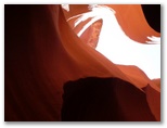
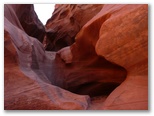
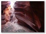
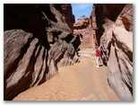
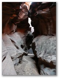
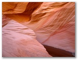
 I returned with Daniel around noon and although we started in with a small group, we soon lost them
and were able to explore the canyon taking pictures for more than two hours. The entrance is
inconspicuous. A sandy wash terminates in a flat ledge of reddish sandstone which drains into a
narrow slot only a foot wide. We started into the slot and immediately descended short flights of
heavy-duty steel steps into a series of dry potholes, each five or ten feet deeper than the previous
I returned with Daniel around noon and although we started in with a small group, we soon lost them
and were able to explore the canyon taking pictures for more than two hours. The entrance is
inconspicuous. A sandy wash terminates in a flat ledge of reddish sandstone which drains into a
narrow slot only a foot wide. We started into the slot and immediately descended short flights of
heavy-duty steel steps into a series of dry potholes, each five or ten feet deeper than the previous
 one. The rest of the quarter-mile long canyon consists of sinuous sand-floored sections alternating
with more steel steps into dry plunge pools and potholes. The walls are striated by the bedding planes of the
original dunes and sculpted by the gritty flash floods which periodically fill the gorge to
one. The rest of the quarter-mile long canyon consists of sinuous sand-floored sections alternating
with more steel steps into dry plunge pools and potholes. The walls are striated by the bedding planes of the
original dunes and sculpted by the gritty flash floods which periodically fill the gorge to
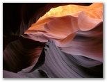
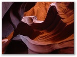 a depth of 30 feet or more. Sunlight echoes down from above bathing the fluted stone in hues
ranging from magenta and violet gray to hot orange and yellow, at least as the camera perceives it.
The camera seemed to translate the shadows and highlights into vivid colors while my eyes simply
recorded "sunny red sandstone" or "shady red sandstone". As we progressed through the canyon
snapping photos like crazy we began to figure out how to capture the colors to best effect. It is a
a depth of 30 feet or more. Sunlight echoes down from above bathing the fluted stone in hues
ranging from magenta and violet gray to hot orange and yellow, at least as the camera perceives it.
The camera seemed to translate the shadows and highlights into vivid colors while my eyes simply
recorded "sunny red sandstone" or "shady red sandstone". As we progressed through the canyon
snapping photos like crazy we began to figure out how to capture the colors to best effect. It is a
 truly amazing place for photographs - even our worst shots were glorious. I've never been in
another place like it, where a camera was essential to bring out the full beauty of the place; I
felt as though the few individuals without cameras were going through the canyon half-blind. We
emerged from the canyon breathless, astonished and satiated with the beauty that we saw in there.
For the next few days, even weeks, I kept wanting to go back in but there wasn't time this trip.
truly amazing place for photographs - even our worst shots were glorious. I've never been in
another place like it, where a camera was essential to bring out the full beauty of the place; I
felt as though the few individuals without cameras were going through the canyon half-blind. We
emerged from the canyon breathless, astonished and satiated with the beauty that we saw in there.
For the next few days, even weeks, I kept wanting to go back in but there wasn't time this trip.
Daniel rested in the motel room for the afternoon. He doesn't think that his fever retuned but he felt and sounded pretty sick nonetheless. While in the canyon he had completely forgotten that he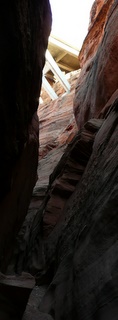 was sick.
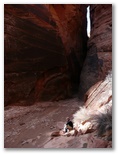
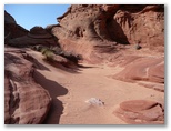 I drove down the six or seven miles south from Page to explore Water Holes canyon. After Antelope
it seemed pretty tame but it was still an interesting hike. The wall are the same reddish sandstone
but scoured only up to five to ten feet and the slot sections of the canyon are typically less than
twenty feet deep. About a half mile up I encountered an impassable dry falls and had to backtrack a
I drove down the six or seven miles south from Page to explore Water Holes canyon. After Antelope
it seemed pretty tame but it was still an interesting hike. The wall are the same reddish sandstone
but scoured only up to five to ten feet and the slot sections of the canyon are typically less than
twenty feet deep. About a half mile up I encountered an impassable dry falls and had to backtrack a
 hundred yard or so, scramble up out of the canyon then drop back in again upstream of the obstacle.
Farther up I came to another tough spot but was able to stem up out of it.
hundred yard or so, scramble up out of the canyon then drop back in again upstream of the obstacle.
Farther up I came to another tough spot but was able to stem up out of it.
About a mile up from the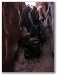 highway bridge the canyon really opened up into a broad sandy wash and though I continued up a ways,
I didn't see any indication that it was going to get narrow again. My mistake - later I learned
that the best parts of the canyon are another mile or two upstream, beyond the wash. I wouldn't
have had time anyhow; the sun was getting low. On the way back I explored downstream past a mangled
highway bridge the canyon really opened up into a broad sandy wash and though I continued up a ways,
I didn't see any indication that it was going to get narrow again. My mistake - later I learned
that the best parts of the canyon are another mile or two upstream, beyond the wash. I wouldn't
have had time anyhow; the sun was getting low. On the way back I explored downstream past a mangled
 car wedged under the bridge to where a 30' drop stopped me. The walls were higher down there but
the light wasn't very good.
car wedged under the bridge to where a 30' drop stopped me. The walls were higher down there but
the light wasn't very good.
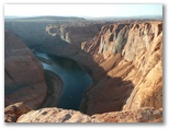
Before returning to Page I hiked out to the Horseshoe Bend overlook, an impressive view of the anomalously clear waters of the Colorado river meandering lazily between 1000' walls of orange sandstone. Back at the motel Daniel didn't feel like eating so I ate alone at Fiesta Mexicana, family Mexican fare a small cut above mediocre. Not sure if Daniel will be well enough to backpack tomorrow, even just 7 miles down Pariah Canyon. We'll see.
Photo galleries of Lower Antelope and Water Holes canyons
Daniel rested in the motel room for the afternoon. He doesn't think that his fever retuned but he felt and sounded pretty sick nonetheless. While in the canyon he had completely forgotten that he
About a mile up from the
Before returning to Page I hiked out to the Horseshoe Bend overlook, an impressive view of the anomalously clear waters of the Colorado river meandering lazily between 1000' walls of orange sandstone. Back at the motel Daniel didn't feel like eating so I ate alone at Fiesta Mexicana, family Mexican fare a small cut above mediocre. Not sure if Daniel will be well enough to backpack tomorrow, even just 7 miles down Pariah Canyon. We'll see.
3/20/2008 Buckskin Gulch UT. 8 miles, 800’ sunny, 55
Photo gallery of our Buckskin Gulch hike
 I give credit to God that we received a permit for Coyote Buttes North this morning. We left Page
around 7:15 and arrived at the Pariah Ranger Station in plenty of time to submit our lottery
application. I figured the outcome might determine whether or not we went ahead with backpacking
into Pariah. Daniel wasn't sure if he was up to even just hiking down the Pariah to the confluence,
the back out again the next day. About 30 people were gathered in the ranger station to find out if
they would be among the ten fortunate individuals permitted access to Coyote Buttes tomorrow. Our
number was 25 out of about 40. A docent rotated the cage contaning the numbered balls and one by
one someone's kid reached in and picked them out. Number 1 was the first one called, then number 25.
That's us - we made it! I had half expected it; with Daniel sick it confirmed our decision not to
do the backpacking trip. Although he couldn't walk the canyon he would at least be able to see
Coyote Buttes and the famous Wave. And he got to see Antelope Canyon which we would likely not have
seen had he not caught David's cold. So things definitely worked out well for us as a result of his
getting sick.
I give credit to God that we received a permit for Coyote Buttes North this morning. We left Page
around 7:15 and arrived at the Pariah Ranger Station in plenty of time to submit our lottery
application. I figured the outcome might determine whether or not we went ahead with backpacking
into Pariah. Daniel wasn't sure if he was up to even just hiking down the Pariah to the confluence,
the back out again the next day. About 30 people were gathered in the ranger station to find out if
they would be among the ten fortunate individuals permitted access to Coyote Buttes tomorrow. Our
number was 25 out of about 40. A docent rotated the cage contaning the numbered balls and one by
one someone's kid reached in and picked them out. Number 1 was the first one called, then number 25.
That's us - we made it! I had half expected it; with Daniel sick it confirmed our decision not to
do the backpacking trip. Although he couldn't walk the canyon he would at least be able to see
Coyote Buttes and the famous Wave. And he got to see Antelope Canyon which we would likely not have
seen had he not caught David's cold. So things definitely worked out well for us as a result of his
getting sick.
 And as if that weren't enough, we managed to spend much of today in Buckskin Gulch. While we waited
for directions to Coyote Buttes, one of the BLM volunteers told me about the Middle Route, an unofficial
trail which provides another access point into the slot canyon. Take the road up Long's Canyon, he explained, and once on top take two lefts and
then a right and follow that road to a trailhead marked by two poles and a wire over the road. A
faint trail leads over to the rim, down over the slickrock and down a wash to the edge of Buckskin
Gulch where a sandy ledgy scrambling route drops the last 100' into the canyon. I figured he may
have been exaggerating the diffculty of the descent, but he wasn't. The route traverses two narrow
sloping shelves directly above the dark abyss of the slot then descends sloping sandy steps down
And as if that weren't enough, we managed to spend much of today in Buckskin Gulch. While we waited
for directions to Coyote Buttes, one of the BLM volunteers told me about the Middle Route, an unofficial
trail which provides another access point into the slot canyon. Take the road up Long's Canyon, he explained, and once on top take two lefts and
then a right and follow that road to a trailhead marked by two poles and a wire over the road. A
faint trail leads over to the rim, down over the slickrock and down a wash to the edge of Buckskin
Gulch where a sandy ledgy scrambling route drops the last 100' into the canyon. I figured he may
have been exaggerating the diffculty of the descent, but he wasn't. The route traverses two narrow
sloping shelves directly above the dark abyss of the slot then descends sloping sandy steps down
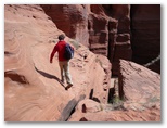 into a gully which drops into the Gulch.
It was not at all obvious where to go after we followed
the wash down to the edge of the Gulch; we followed recent footsteps out of the wash and over to the
descent route. When we first peered over the edge and spotted the floor far below in the darkness
between vertical 100' walls it seemed inconceivable that we could get down there but a few minutes
later we were standing in the bright sunshine at a righ angle bend in the canyon, relieved to be on
flat ground with nowhere to fall.
into a gully which drops into the Gulch.
It was not at all obvious where to go after we followed
the wash down to the edge of the Gulch; we followed recent footsteps out of the wash and over to the
descent route. When we first peered over the edge and spotted the floor far below in the darkness
between vertical 100' walls it seemed inconceivable that we could get down there but a few minutes
later we were standing in the bright sunshine at a righ angle bend in the canyon, relieved to be on
flat ground with nowhere to fall.
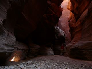
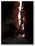
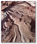
We explored upstream a few hundred yards. The streambed was ten to twenty feet wide at that point, mostly gravel and sand with a thin coating of mud in all the low spots. The walls were sometimes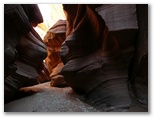 smooth but more often carved into ribs and hollows, half-potholes cut like niches into the walls.
The fluting is coarser, more massive, and the stream bed generally much wider, than Antelope or
Water Holes canyons. At least some of the flash floods must be massive as well to have wedged logs
across the canyon thirty feet overhead. We aren't the first hikers here; a trampled-out foot trail
follows the driest line between the muddy half-pools nestled into the wall niches.
smooth but more often carved into ribs and hollows, half-potholes cut like niches into the walls.
The fluting is coarser, more massive, and the stream bed generally much wider, than Antelope or
Water Holes canyons. At least some of the flash floods must be massive as well to have wedged logs
across the canyon thirty feet overhead. We aren't the first hikers here; a trampled-out foot trail
follows the driest line between the muddy half-pools nestled into the wall niches.
 We decide to hike downstream. I'd like to get to the confluence even if Daniel isn't up to going
that far. We hike pretty steadily for about an hour. The going is mostly easy, dry and smooth, the
mud curling up in crunchy flakes and the pools receding into mud-floored puddles of clear greenish
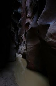
water. The walls generally rise about 100' overhead, sometimes higher or lower. At ground level
they're usually about 20' apart, often more, though overhead they sometimes converge to block out
the sky. Sunlight iluminates the canyon walls and floor from time to time, welcome relief from the
dark and somewhat chilly shadows. Aound noon we stop for a bit of lunch and Daniel decides to wait
while I go on.
We decide to hike downstream. I'd like to get to the confluence even if Daniel isn't up to going
that far. We hike pretty steadily for about an hour. The going is mostly easy, dry and smooth, the
mud curling up in crunchy flakes and the pools receding into mud-floored puddles of clear greenish
water. The walls generally rise about 100' overhead, sometimes higher or lower. At ground level
they're usually about 20' apart, often more, though overhead they sometimes converge to block out
the sky. Sunlight iluminates the canyon walls and floor from time to time, welcome relief from the
dark and somewhat chilly shadows. Aound noon we stop for a bit of lunch and Daniel decides to wait
while I go on.
I jog and walk another 25 minutes down-canyon, stopping for photos and slowing in a few spots to negotiate boulder jams. The walls get taller and begin to close in and the pools get larger. After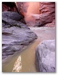
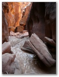 a short dark stretch where the walls are only five feet apart and extend up 150' or more, I come to
a 40' long pool of opaque olive-green water which blocks the narrow canyon from wall to wall. I consider
trying to stem over it but it's too long and the fluting of the walls makes for non-negotiable
overhangs. I take off my hiking shoes, roll up my pants and wade in, a foot deep on the first step
a short dark stretch where the walls are only five feet apart and extend up 150' or more, I come to
a 40' long pool of opaque olive-green water which blocks the narrow canyon from wall to wall. I consider
trying to stem over it but it's too long and the fluting of the walls makes for non-negotiable
overhangs. I take off my hiking shoes, roll up my pants and wade in, a foot deep on the first step
 and getting deeper. I back out and strip from the waist down, rolling my pants and shoes in a
bundle which I can carry in one hand leaving the other free to brace myself against one wall or the
other. My feet slide into several inches of slippery mud. The bottom of the pool slopes steeply
towards both walls so I try to keep to the highest ground as the water rises briefly to my hips.
Brrr, that was a shock. By the time I step out at the far end my feet and lower legs are beginning
to throb from the cold and my toes are already getting numb. I rub my feet in the icy water to get
the slimy mud off my toes then pull my pants and shoes back on. Bad decision, leaving the chest
waders back at the lunch spot with Daniel. About a hundred yards farther down the canyon I come to
another pool and that does it. I turn around. Feeling has just returned to my toes when I get back
to the 40' pool. Again I undress, slither along the muddy bottom, rinse off, put everything back on
and head back to Daniel. He's reading in the sunshine. A solo hiker with a southern accent passes
us, wearing a wetsuit, then three guys in shorts backpacking down to Lee's Ferry. They're in for a
shock. We don't see anyone else all day.
and getting deeper. I back out and strip from the waist down, rolling my pants and shoes in a
bundle which I can carry in one hand leaving the other free to brace myself against one wall or the
other. My feet slide into several inches of slippery mud. The bottom of the pool slopes steeply
towards both walls so I try to keep to the highest ground as the water rises briefly to my hips.
Brrr, that was a shock. By the time I step out at the far end my feet and lower legs are beginning
to throb from the cold and my toes are already getting numb. I rub my feet in the icy water to get
the slimy mud off my toes then pull my pants and shoes back on. Bad decision, leaving the chest
waders back at the lunch spot with Daniel. About a hundred yards farther down the canyon I come to
another pool and that does it. I turn around. Feeling has just returned to my toes when I get back
to the 40' pool. Again I undress, slither along the muddy bottom, rinse off, put everything back on
and head back to Daniel. He's reading in the sunshine. A solo hiker with a southern accent passes
us, wearing a wetsuit, then three guys in shorts backpacking down to Lee's Ferry. They're in for a
shock. We don't see anyone else all day.
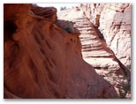 Back at our entry point we explore the south side of the canyon and find a route out on that side as
well, complete with little hollows worn into the rock - footholds. By their regular placement and
shape, it is apparent that they are neither naturally nor recently formed. It appears that the
Middle Route is actually the north half of an ancient canyon crossing route and that those who used
it cut out footholds to make the passage easier. We climb back down to a shelf about ten feet above
the canyon floor and study the route we will be ascending out of the canyon. About fifty feet up
the cliff across the way we spot a dark hollow with a couple of yellowish things hanging from the
roof - right above where Daniel had found an old sour-smelling chunk of honeycomb, brittle and dry,
on the way down. With binoculars the yellowish things are clearly identfiable as more honeycombs.
I recall that one characteristic of Africanized "killer" bees is their habit of hanging their combs
out in the open like that. We watch for a while, see no bees. Good thing, because on the way up we
pass just 25 feet below the old hive. The ascent up from the gully is easier than the descent was.
Back at our entry point we explore the south side of the canyon and find a route out on that side as
well, complete with little hollows worn into the rock - footholds. By their regular placement and
shape, it is apparent that they are neither naturally nor recently formed. It appears that the
Middle Route is actually the north half of an ancient canyon crossing route and that those who used
it cut out footholds to make the passage easier. We climb back down to a shelf about ten feet above
the canyon floor and study the route we will be ascending out of the canyon. About fifty feet up
the cliff across the way we spot a dark hollow with a couple of yellowish things hanging from the
roof - right above where Daniel had found an old sour-smelling chunk of honeycomb, brittle and dry,
on the way down. With binoculars the yellowish things are clearly identfiable as more honeycombs.
I recall that one characteristic of Africanized "killer" bees is their habit of hanging their combs
out in the open like that. We watch for a while, see no bees. Good thing, because on the way up we
pass just 25 feet below the old hive. The ascent up from the gully is easier than the descent was.
 Traversing the narrow shelves again I cannot resist peering into the darkness below and savoring the
qualm of fear that grips my gut. Safely across, we work our way up the sand and ledges of the ridge
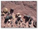
between the two washes. In weathered hollows between ribs of the sandstone we find collections of
pebbles half-polished to an oily sheen. There are rounded pebbles of brown quartzite, irregular
chunks of a black stone, bits of gneiss and quartz and even a few chips of agate looking as though
they might have been worked. Who knows how long it takes for wind, water and sand to polish them
like that? Possibly even God created them right in this hollow and they haven't left it since,
just picked up a little polish over the centuries.
Traversing the narrow shelves again I cannot resist peering into the darkness below and savoring the
qualm of fear that grips my gut. Safely across, we work our way up the sand and ledges of the ridge
between the two washes. In weathered hollows between ribs of the sandstone we find collections of
pebbles half-polished to an oily sheen. There are rounded pebbles of brown quartzite, irregular
chunks of a black stone, bits of gneiss and quartz and even a few chips of agate looking as though
they might have been worked. Who knows how long it takes for wind, water and sand to polish them
like that? Possibly even God created them right in this hollow and they haven't left it since,
just picked up a little polish over the centuries.
Photo gallery of our Buckskin Gulch hike
We explored upstream a few hundred yards. The streambed was ten to twenty feet wide at that point, mostly gravel and sand with a thin coating of mud in all the low spots. The walls were sometimes
I jog and walk another 25 minutes down-canyon, stopping for photos and slowing in a few spots to negotiate boulder jams. The walls get taller and begin to close in and the pools get larger. After
3/21/2008 Coyote Buttes North UT. 7 miles, 2100’ sunny, 40-55
Photo gallery of our Coyote Buttes hike
 We camped overnight in a semi-flat barren area above the Wire Pass trailhead parking lot. I fired
up the stove and boiled water for hot carob drink, past-dated vegetable lasagna and corn chowder.
Daniel burned his tongue on the chowder. I drank lots of hot carob and had to get up every hour or
during the night. The moon was full and bright but the air was near freezing and a breeze blew
steadily. By morning I began to get cold even in my 0F bag. Nose all stuffed up too
although one side cleared up around 5AM so I could breathe.
We camped overnight in a semi-flat barren area above the Wire Pass trailhead parking lot. I fired
up the stove and boiled water for hot carob drink, past-dated vegetable lasagna and corn chowder.
Daniel burned his tongue on the chowder. I drank lots of hot carob and had to get up every hour or
during the night. The moon was full and bright but the air was near freezing and a breeze blew
steadily. By morning I began to get cold even in my 0F bag. Nose all stuffed up too
although one side cleared up around 5AM so I could breathe.
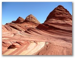
The sun rose at 7AM Arizona time. We ate granola, packed up and were hiking down Wire Pass wash by 8AM. Beautiful morning - blue sky, red sandstone outcrops amidst olive green junipers. About a half mile down the wash the trail to Coyote Buttes climbs a gentle hillside and continues across orange sand for another half mile before reaching a slabby sandstone ridge. For the next five hours we were hiking on sandstone, sandstone in an amazing variety of textures and colors. The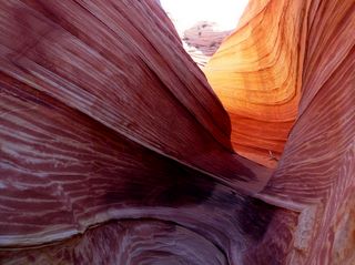 "Wave", a short branched trough of pink and cream striped stone sanded smooth by the wind, was the
most spectacular formation but we found many other strange and wonderful patterns in that crazy
landscape. There were pillows, ribs, knives, swirls, ribbons and plates, mushrooms, muffins,
turtles and teepees and even a few windows and arches. We found sand dunes nestled in hollows and
pools of water out on the flats, wind-fluted fins and water-carved gullies and grooves rubbed into
"Wave", a short branched trough of pink and cream striped stone sanded smooth by the wind, was the
most spectacular formation but we found many other strange and wonderful patterns in that crazy
landscape. There were pillows, ribs, knives, swirls, ribbons and plates, mushrooms, muffins,
turtles and teepees and even a few windows and arches. We found sand dunes nestled in hollows and
pools of water out on the flats, wind-fluted fins and water-carved gullies and grooves rubbed into
 the stone by wind-blown branches. Foot candy abounded - shelves, ridges, steps, slots, ramps, lumps
and domes - a foot-friendly landscape that just begs to be trodden. Barefoot would have been fun
but I didn't think to take off my hiking shoes.
the stone by wind-blown branches. Foot candy abounded - shelves, ridges, steps, slots, ramps, lumps
and domes - a foot-friendly landscape that just begs to be trodden. Barefoot would have been fun
but I didn't think to take off my hiking shoes.
Daniel wasn't feeling very energetic so he sat and read for an hour and a half while I explored over to the right of the big crack above the Wave and around on top for a while, then down the face to the left of the crack. Up on top I found several wind-carved caves and arches a short distance south of the headwall above the Wave. Took more photos.
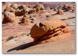
 On the way back Daniel and I hiked down the narrow stream gully below the Wave then up to some
three-toed dinosaur tracks right across the valley from the Wave, then up into a bowl not evident
from below, on the big pastel-colored sandstone face which was on our right as we hiked in. Lots
On the way back Daniel and I hiked down the narrow stream gully below the Wave then up to some
three-toed dinosaur tracks right across the valley from the Wave, then up into a bowl not evident
from below, on the big pastel-colored sandstone face which was on our right as we hiked in. Lots
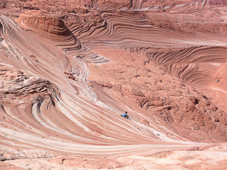 of amazing swirly stone and some intriguing ribs and angular blocks composed of intersecting sheets
of harder stone left after the matrix had eroded away. Hard to describe, easier to portray in photos.
On the way out across the orange sand ridges we spotted chips of white, gray, orange and yellow
agate, some
of which looked worked.
of amazing swirly stone and some intriguing ribs and angular blocks composed of intersecting sheets
of harder stone left after the matrix had eroded away. Hard to describe, easier to portray in photos.
On the way out across the orange sand ridges we spotted chips of white, gray, orange and yellow
agate, some
of which looked worked.
We were tired and dehydrated when we got back to the car. Even my nose had almost stopped running although my eyes kept itching. At the trailhead we met the BLM volunteer who had told me about the Middle Route yesterday, so I told him about the ancient footholds and the killer bee hive. He knew about the footholds - apparently it was a long-used thoroughfare for generations of aboriginal people. He also told me about petroglyphs on the wall along the descent, one of a figure with arms flailing as if falling, an ancient equivalent of a highway warning sign. We'll have to look for it next time.
Heading west back towards Las Vegas we stopped for Mexican food at Fernandos in Kanab, vegetarian though not particularly good, then drove through Zion on Hwy 9. The signs said we'd have to pay $25 to drive through the park but nobody was home to collect our money. We drove by whole mountains of slickrock sandstone; had we not already spent six hours hiking around on slickrock earlier in the day I'd have been sorely tempted to stop and run around. Zion definitely warrants further exploration. Down at the park entrance and in Springdale all the campgrounds and motels were full. Not sure what was attracting all the people, but Zion seemed to be packed. We'd considered staying in a motel but a few miles below Springdale I found a camping site along the river so we're in the tent again with the full moon rising, cars zooming by on the highway and lots of fellow campers burning smoky fires of greasewood brush.
Photo gallery of our Coyote Buttes hike
The sun rose at 7AM Arizona time. We ate granola, packed up and were hiking down Wire Pass wash by 8AM. Beautiful morning - blue sky, red sandstone outcrops amidst olive green junipers. About a half mile down the wash the trail to Coyote Buttes climbs a gentle hillside and continues across orange sand for another half mile before reaching a slabby sandstone ridge. For the next five hours we were hiking on sandstone, sandstone in an amazing variety of textures and colors. The
Daniel wasn't feeling very energetic so he sat and read for an hour and a half while I explored over to the right of the big crack above the Wave and around on top for a while, then down the face to the left of the crack. Up on top I found several wind-carved caves and arches a short distance south of the headwall above the Wave. Took more photos.
We were tired and dehydrated when we got back to the car. Even my nose had almost stopped running although my eyes kept itching. At the trailhead we met the BLM volunteer who had told me about the Middle Route yesterday, so I told him about the ancient footholds and the killer bee hive. He knew about the footholds - apparently it was a long-used thoroughfare for generations of aboriginal people. He also told me about petroglyphs on the wall along the descent, one of a figure with arms flailing as if falling, an ancient equivalent of a highway warning sign. We'll have to look for it next time.
Heading west back towards Las Vegas we stopped for Mexican food at Fernandos in Kanab, vegetarian though not particularly good, then drove through Zion on Hwy 9. The signs said we'd have to pay $25 to drive through the park but nobody was home to collect our money. We drove by whole mountains of slickrock sandstone; had we not already spent six hours hiking around on slickrock earlier in the day I'd have been sorely tempted to stop and run around. Zion definitely warrants further exploration. Down at the park entrance and in Springdale all the campgrounds and motels were full. Not sure what was attracting all the people, but Zion seemed to be packed. We'd considered staying in a motel but a few miles below Springdale I found a camping site along the river so we're in the tent again with the full moon rising, cars zooming by on the highway and lots of fellow campers burning smoky fires of greasewood brush.
3/22/2008 Springdale UT to Las Vegas NV and home. sunny, 40-60
We hit the road fairly early, drove back through St George and the Virgin River gorge then stopped at Littlefield just west of the gorge to fix breakfast and photograph flowers. The pink and white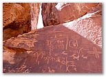 flowers around the Littlefield/Beaverdam exit just east of the Virgin River bridge were the best
we'd seen on the whole whole trip. I took an extra hour or so for a little birding after we spotted
a brilliant Vermilion Flycatcher in a creosote bush. Bird activity was tapering off quickly by the
time I got out but I was surprised to find a pair of Common Black Hawks, only my second sighting
outside of Barranca Del Cobre in Mexico.
flowers around the Littlefield/Beaverdam exit just east of the Virgin River bridge were the best
we'd seen on the whole whole trip. I took an extra hour or so for a little birding after we spotted
a brilliant Vermilion Flycatcher in a creosote bush. Bird activity was tapering off quickly by the
time I got out but I was surprised to find a pair of Common Black Hawks, only my second sighting
outside of Barranca Del Cobre in Mexico.
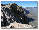
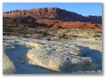
On the way back to Las Vegas I made a detour out to Valley of Fire State Park where we found the brightest orange sandstone outcrops I've ever seen. We didn't have time to check out the easy and accessible slot canyon there but we did linger long enough for Daniel to take a shower. I was worried that we'd get busted because the campground showers might not be open to the public, so I dropped him off and drove out to see the nearby petroglyphs. I was impressed with the petroglyphs and Daniel was happy to get clean but our little side trip made us an hour late meeting Daniel's college friend Alex and his father Alan back at Red Rocks in Las Vegas.
Red Rocks was packed too. We left our car at headquarters and drove up to the Turtlehead trailhead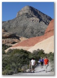 parking area in Alan's nearly silent Prius. Cars were parked all along the loop drive in that area
but we were able to sneak into a recently-vacated space in the parking lot. We had several hours
and everyone seemed up to a little scrambling so we headed up to the big white peak back and to the
parking area in Alan's nearly silent Prius. Cars were parked all along the loop drive in that area
but we were able to sneak into a recently-vacated space in the parking lot. We had several hours
and everyone seemed up to a little scrambling so we headed up to the big white peak back and to the
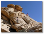
 right. It had been several years since I'd been up it so I wasn't sure of the route but I think we
managed to start up in the right area. It was a tougher scramble than I remembered so we only went
about half way up. Alex and Daniel went a little higher than we did; Alan and I stayed down below
and took photos.
We ate some lunch up on the rocks somewhere; Alan had brought these delicious little sushi-like
packets of sticky rice and tuna fish wrapped in Nori which he shared with me, inspiring me to
buy some Nori and try my hand at making them.
right. It had been several years since I'd been up it so I wasn't sure of the route but I think we
managed to start up in the right area. It was a tougher scramble than I remembered so we only went
about half way up. Alex and Daniel went a little higher than we did; Alan and I stayed down below
and took photos.
We ate some lunch up on the rocks somewhere; Alan had brought these delicious little sushi-like
packets of sticky rice and tuna fish wrapped in Nori which he shared with me, inspiring me to
buy some Nori and try my hand at making them.
We hit the road fairly early, drove back through St George and the Virgin River gorge then stopped at Littlefield just west of the gorge to fix breakfast and photograph flowers. The pink and white
On the way back to Las Vegas I made a detour out to Valley of Fire State Park where we found the brightest orange sandstone outcrops I've ever seen. We didn't have time to check out the easy and accessible slot canyon there but we did linger long enough for Daniel to take a shower. I was worried that we'd get busted because the campground showers might not be open to the public, so I dropped him off and drove out to see the nearby petroglyphs. I was impressed with the petroglyphs and Daniel was happy to get clean but our little side trip made us an hour late meeting Daniel's college friend Alex and his father Alan back at Red Rocks in Las Vegas.
Red Rocks was packed too. We left our car at headquarters and drove up to the Turtlehead trailhead